


Autopedestres : Beckerich

Visit Luxembourg
Randonnées de Visit Luxembourg. GUIDE+
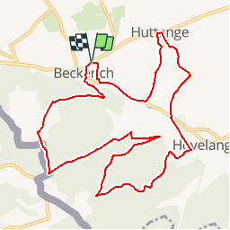

Longueur
11,6 km

Altitude max
407 m

Dénivelé positif
297 m
Km-Effort
15,5 km

Altitude min
275 m

Dénivelé négatif
298 m
Boucle
Oui
Date de création :
2014-12-10 00:00:00.0
Dernière modification :
2014-12-10 00:00:00.0
--
Difficulté : Inconnu

Application GPS de randonnée GRATUITE
 SityTrail
IGN / Instituts géographiques
SityTrail Plus
Le monde est à vous
À propos
Randonnée Marche de 11,6 km à découvrir à Inconnu, Canton Redange, Beckerich. Cette randonnée est proposée par Visit Luxembourg.
Description
Fermé pour travaux jusque fin novembre 2012


Localisation
Pays :
Luxembourg
Région :
Inconnu
Département/Province :
Canton Redange
Commune :
Beckerich
Localité :
Unknown
Départ:(Dec)
Départ:(UTM)
707873 ; 5512821 (31U) N.
Commentaires