


Manternacher Fiels

Visit Luxembourg
Randonnées de Visit Luxembourg. GUIDE+
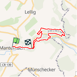

Longueur
5,8 km

Altitude max
276 m

Dénivelé positif
172 m
Km-Effort
8 km

Altitude min
182 m

Dénivelé négatif
157 m
Boucle
Non
Date de création :
2014-12-10 00:00:00.0
Dernière modification :
2014-12-10 00:00:00.0
--
Difficulté : Inconnu

Application GPS de randonnée GRATUITE
 SityTrail
IGN / Instituts géographiques
SityTrail Plus
Le monde est à vous
À propos
Randonnée Marche de 5,8 km à découvrir à Inconnu, Canton Grevenmacher, Manternach. Cette randonnée est proposée par Visit Luxembourg.
Description
Manternacher Fiels
Localisation
Pays :
Luxembourg
Région :
Inconnu
Département/Province :
Canton Grevenmacher
Commune :
Manternach
Localité :
Unknown
Départ:(Dec)
Départ:(UTM)
314319 ; 5509286 (32U) N.
Commentaires