


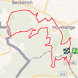
Pistes_VTT : Beckerich 12 km

Visit Luxembourg
Randonnées de Visit Luxembourg. GUIDE+

Longueur
12,9 km

Altitude max
414 m

Dénivelé positif
362 m
Km-Effort
17,8 km

Altitude min
289 m

Dénivelé négatif
364 m
Boucle
Oui
Date de création :
2014-12-10 00:00:00.0
Dernière modification :
2014-12-10 00:00:00.0
--
Difficulté : Inconnu

Application GPS de randonnée GRATUITE
 SityTrail
IGN / Instituts géographiques
SityTrail Plus
Le monde est à vous
À propos
Randonnée V.T.T. de 12,9 km à découvrir à Inconnu, Canton Redange, Beckerich. Cette randonnée est proposée par Visit Luxembourg.
Description
Parcours de VTT 12 km de Beckerich à Hovelange, Schweich, Hobscheid et retour
Localisation
Pays :
Luxembourg
Région :
Inconnu
Département/Province :
Canton Redange
Commune :
Beckerich
Localité :
Unknown
Départ:(Dec)
Départ:(UTM)
709828 ; 5510506 (31U) N.
Commentaires