


Pistes_VTT : VTT_Echternach

Visit Luxembourg
Randonnées de Visit Luxembourg. GUIDE+
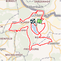

Longueur
23 km

Altitude max
389 m

Dénivelé positif
524 m
Km-Effort
30 km

Altitude min
159 m

Dénivelé négatif
525 m
Boucle
Oui
Date de création :
2014-12-10 00:00:00.0
Dernière modification :
2014-12-10 00:00:00.0
--
Difficulté : Inconnu

Application GPS de randonnée GRATUITE
 SityTrail
IGN / Instituts géographiques
SityTrail Plus
Le monde est à vous
À propos
Randonnée V.T.T. de 23 km à découvrir à Inconnu, Canton Echternach, Echternach. Cette randonnée est proposée par Visit Luxembourg.
Localisation
Pays :
Luxembourg
Région :
Inconnu
Département/Province :
Canton Echternach
Commune :
Echternach
Localité :
Unknown
Départ:(Dec)
Départ:(UTM)
314015 ; 5519766 (32U) N.
Commentaires