


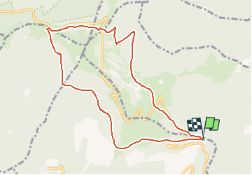
Firstacker - Le Haag - Sattelfels- Gerstacker et retour

patrickbeyrath
Utilisateur


1h37
Difficulté : Moyen

Application GPS de randonnée GRATUITE
 SityTrail
IGN / Instituts géographiques
SityTrail Plus
Le monde est à vous
À propos
Randonnée Marche de 9,5 km à découvrir à Grand Est, Haut-Rhin, Goldbach-Altenbach. Cette randonnée est proposée par patrickbeyrath.
Description
Parking du Firstacker - GR5 rectangle rouge ferme du Ballon puis losange rouge direction Judenhut puis au croisement avec rectangle rouge blanc rouge prendre à gauche direction Grand Ballon-Le Haag . Arrivé au Haag prendre chalet jaune jusqu'à l'abri Sattelfels et après prendre rond jaune Gertsacker et retour parking
Localisation
Commentaires