Randonnée Marche Oderen - Oderen - autour du Gommkopf - Chemin de Laffe- Strasshisel - Photo

Oderen - autour du Gommkopf - Chemin de Laffe- Strasshisel

 patrickbeyrath
patrickbeyrath

Utilisateur

© OpenStreetMap contributors
Longueur
Longueur
9,2 km
Altitude max
Altitude max
807 m
Dénivelé positif
Dénivelé positif
446 m
Km-Effort
Km-Effort  
15,1 km
Altitude min
Altitude min
470 m
Dénivelé négatif
Dénivelé négatif
449 m
Boucle
Boucle
Oui
Date de création :
2018-11-30 08:15:38.777
Dernière modification :
2018-11-30 09:15:06.351

(0 Avis)

Marche
Marche
3h05
Difficulté : Difficile

Scannez ce code QR pour ouvrir la randonnée dans l'application SityTrail

Application GPS de randonnée GRATUITE

Logo SityTrail SityTrail

IGN / Instituts géographiques

Télécharger SityTrail sur l'App Store Télécharger SityTrail sur Google Play

Logo SityTrail SityTrail Plus

Le monde est à vous

Télécharger SityTrail sur l'App Store Télécharger SityTrail sur Google Play Télécharger SityTrail sur Huawei AppGallery

À propos

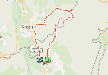
Randonnée Marche de 9,2 km à découvrir à Grand Est, Haut-Rhin, Oderen. Cette randonnée est proposée par patrickbeyrath.

Description

Parking arboriculteurs, rue de Vontay - triangle bleu Uhufels - Pfaffenkopf - triangle jaune Gommkopf - Chemin de Laffe puis rectangle rouge blanc rouge Holtzplatz aller direction Laffe et prendre à gauche indication Strasshisel et aller juste à l'abri et prendre le retour le long de Kruth- Oderen-

Profil altimétrique

Localisation

Pays :
France
Région :
Grand Est
Département/Province :
Haut-Rhin
Commune :
Oderen
Localité :
Unknown
Départ:(UTM)
348650 ; 5308881 (32T) N.


Fermer
Mes abonnements