


St Léger Vauban 18.32

togolo28
Utilisateur
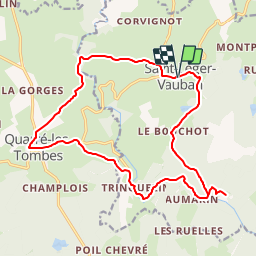

Longueur
18,3 km

Altitude max
493 m

Dénivelé positif
364 m
Km-Effort
23 km

Altitude min
342 m

Dénivelé négatif
364 m
Boucle
Oui
Date de création :
2019-01-13 15:41:15.614
Dernière modification :
2019-01-13 15:51:13.146
--
Difficulté : Moyen

Application GPS de randonnée GRATUITE
 SityTrail
IGN / Instituts géographiques
SityTrail Plus
Le monde est à vous
À propos
Randonnée A pied de 18,3 km à découvrir à Bourgogne-Franche-Comté, Yonne, Saint-Léger-Vauban. Cette randonnée est proposée par togolo28.
Description
Départ du village natal de Sébastien Le Prestre dit "Vauban".
Localisation
Pays :
France
Région :
Bourgogne-Franche-Comté
Département/Province :
Yonne
Commune :
Saint-Léger-Vauban
Localité :
Unknown
Départ:(Dec)
Départ:(UTM)
579017 ; 5248546 (31T) N.
Commentaires