


odeigne 1

lamortgregory
Utilisateur
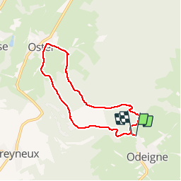

Longueur
6,2 km

Altitude max
553 m

Dénivelé positif
174 m
Km-Effort
8,5 km

Altitude min
446 m

Dénivelé négatif
175 m
Boucle
Oui
Date de création :
2019-02-03 14:44:31.165
Dernière modification :
2019-02-13 22:58:34.901
1h44
Difficulté : Moyen

Application GPS de randonnée GRATUITE
 SityTrail
IGN / Instituts géographiques
SityTrail Plus
Le monde est à vous
À propos
Randonnée Marche de 6,2 km à découvrir à Wallonie, Luxembourg, Manhay. Cette randonnée est proposée par lamortgregory.
Localisation
Pays :
Belgique
Région :
Wallonie
Département/Province :
Luxembourg
Commune :
Manhay
Localité :
Odeigne
Départ:(Dec)
Départ:(UTM)
691009 ; 5570923 (31U) N.
Commentaires