Randonnée Marche Saint-Christophe-sur-Guiers - La Ruchere - Col de l'Allienard - Photo
 bruno.saget
bruno.saget

Utilisateur

© OpenStreetMap contributors
Longueur
Longueur
11,9 km
Altitude max
Altitude max
1570 m
Dénivelé positif
Dénivelé positif
510 m
Km-Effort
Km-Effort  
18,7 km
Altitude min
Altitude min
1146 m
Dénivelé négatif
Dénivelé négatif
509 m
Boucle
Boucle
Oui
Date de création :
2019-02-19 11:47:46.765
Dernière modification :
2019-02-19 16:47:36.691

(0 Avis)

Marche
Marche
4h34
Difficulté : Moyen

Scannez ce code QR pour ouvrir la randonnée dans l'application SityTrail

Application GPS de randonnée GRATUITE

Logo SityTrail SityTrail

IGN / Instituts géographiques

Télécharger SityTrail sur l'App Store Télécharger SityTrail sur Google Play

Logo SityTrail SityTrail World

Le monde est à vous

Télécharger SityTrail sur l'App Store Télécharger SityTrail sur Google Play Télécharger SityTrail sur Huawei AppGallery

À propos

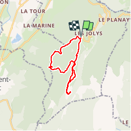
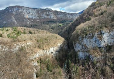
Randonnée Marche de 11,9 km à découvrir à Auvergne-Rhône-Alpes, Isère, Saint-Christophe-sur-Guiers. Cette randonnée est proposée par bruno.saget.

Description

Sentier raquette rouge (3) au début jusqu au col de l Allienard. Puis sentier raquette bleu (2) pour retour, sans passer par le col de la Ruchere.
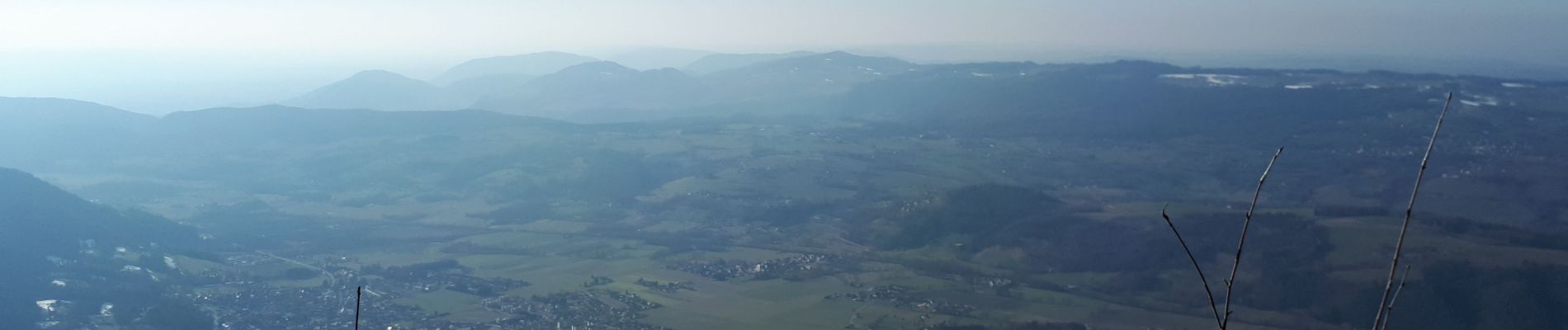
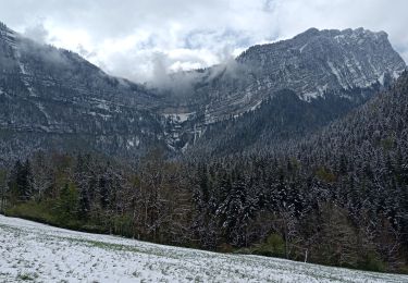
Magnifique vues sur Grand Som et Petit Som. Pas besoin de raquettes car neige tassée.

Profil altimétrique

Photos

Localisation

Pays :
France
Région :
Auvergne-Rhône-Alpes
Département/Province :
Isère
Commune :
Saint-Christophe-sur-Guiers
Localité :
Unknown
Départ:(UTM)
718862 ; 5032246 (31T) N.

Randonnées à proximité

Randonnée Raquettes à neige Saint-Christophe-sur-Guiers - Le Belvédère d'Arpison - Photo
Raquettes à neige
patjobou

Raquettes à neige

Moyen
(1)
Saint-Christophe-sur-Guiers, Auvergne-Rhône-Alpes, Isère, France
11,1 km | 17,4 km-effort
4h 43min
Oui
Randonnée Marche Saint-Pierre-d'Entremont - Le Grand Som 2026m, depuis Saint-Philibert - Photo
Marche
tracegps

Marche

Difficile
(1)
Saint-Pierre-d'Entremont, Auvergne-Rhône-Alpes, Isère, France
11,2 km | 25 km-effort
7h 0min
Oui
Randonnée Marche Saint-Pierre-d'Entremont - Roche Veyrand par les Clapiers, 1429m - Photo
Marche
tracegps

Marche

Difficile
(1)
Saint-Pierre-d'Entremont, Auvergne-Rhône-Alpes, Savoie, France
4,8 km | 14,3 km-effort
4h 10min
Oui
Randonnée Marche Saint-Christophe-sur-Guiers - Petit Som 1772m,  depuis La Ruchère - Photo
Marche
tracegps

Marche

Moyen
(2)
Saint-Christophe-sur-Guiers, Auvergne-Rhône-Alpes, Isère, France
6 km | 13,2 km-effort
3h 30min
Oui
Randonnée Marche Saint-Christophe-sur-Guiers - Petit Som par le Col de la Ruchère - Photo
Marche
simon.paume

Marche

Moyen
(2)
Saint-Christophe-sur-Guiers, Auvergne-Rhône-Alpes, Isère, France
7,1 km | 15,2 km-effort
3h 5min
Oui
Randonnée sport Saint-Christophe - La grotte - Photo
sport
Biquette73

sport

Très facile
Saint-Christophe, Auvergne-Rhône-Alpes, Savoie, France
8,9 km | 14,1 km-effort
Inconnu
Non
Randonnée Marche Saint-Pierre-d'Entremont - Cirque de Saint Même depuis Saint Pierre d'Entremont - Photo
Marche
chuck

Marche

Moyen
Saint-Pierre-d'Entremont, Auvergne-Rhône-Alpes, Isère, France
10,9 km | 17,2 km-effort
4h 22min
Oui
Randonnée Marche Saint-Christophe - la voie SARDE / tunnel des l'Echelles /st Christophe sur Guiers - Photo
Marche
okfred26

Marche

Très difficile
Saint-Christophe, Auvergne-Rhône-Alpes, Savoie, France
15,1 km | 23 km-effort
5h 12min
Oui
Randonnée Marche Saint-Christophe - 190323 Boucle voie Sarde - Photo
Marche
mzonzon05

Marche

Difficile
Saint-Christophe, Auvergne-Rhône-Alpes, Savoie, France
9,7 km | 15,6 km-effort
3h 50min
Oui


Fermer
Mes abonnements