


20190410cassis

michelelfn
Utilisateur
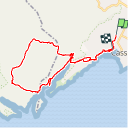

Longueur
10,5 km

Altitude max
193 m

Dénivelé positif
329 m
Km-Effort
14,9 km

Altitude min
4 m

Dénivelé négatif
357 m
Boucle
Non
Date de création :
2019-04-10 08:21:40.502
Dernière modification :
2019-04-10 14:56:54.528
6h31
Difficulté : Très facile

Application GPS de randonnée GRATUITE
 SityTrail
IGN / Instituts géographiques
SityTrail Plus
Le monde est à vous
À propos
Randonnée Marche de 10,5 km à découvrir à Provence-Alpes-Côte d'Azur, Bouches-du-Rhône, Cassis. Cette randonnée est proposée par michelelfn.
Localisation
Pays :
France
Région :
Provence-Alpes-Côte d'Azur
Département/Province :
Bouches-du-Rhône
Commune :
Cassis
Localité :
Unknown
Départ:(Dec)
Départ:(UTM)
706107 ; 4788198 (31T) N.
Commentaires