Randonnée Marche Lanuéjols - Château de Chapieu - Photo

Château de Chapieu

 jgiraud
jgiraud

Utilisateur

© OpenStreetMap contributors
Longueur
Longueur
6,6 km
Altitude max
Altitude max
997 m
Dénivelé positif
Dénivelé positif
200 m
Km-Effort
Km-Effort  
9,3 km
Altitude min
Altitude min
809 m
Dénivelé négatif
Dénivelé négatif
202 m
Boucle
Boucle
Oui
Date de création :
2019-04-13 12:38:48.677
Dernière modification :
2019-04-13 15:42:40.266

(0 Avis)

Marche
Marche
2h44
Difficulté : Facile

Scannez ce code QR pour ouvrir la randonnée dans l'application SityTrail

Application GPS de randonnée GRATUITE

Logo SityTrail SityTrail

IGN / Instituts géographiques

Télécharger SityTrail sur l'App Store Télécharger SityTrail sur Google Play

Logo SityTrail SityTrail World

Le monde est à vous

Télécharger SityTrail sur l'App Store Télécharger SityTrail sur Google Play Télécharger SityTrail sur Huawei AppGallery

À propos

Randonnée Marche de 6,6 km à découvrir à Occitanie, Lozère, Lanuéjols. Cette randonnée est proposée par jgiraud.

Description

à la découverte des ruines du château de Chapieu

Profil altimétrique

Localisation

Pays :
France
Région :
Occitanie
Département/Province :
Lozère
Commune :
Lanuéjols
Localité :
Unknown
Départ:(UTM)
544567 ; 4927212 (31T) N.

Randonnées à proximité

Randonnée Marche Badaroux - Pelgeires,le Born la Rouviere  - Photo
Marche
tyntyn

Marche

Moyen
Badaroux, Occitanie, Lozère, France
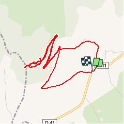
12,5 km | 18,1 km-effort
3h 6min
Oui
Randonnée Marche Sainte-Hélène - mardi - Photo
Marche
olivier78000

Marche

Très facile
Sainte-Hélène, Occitanie, Lozère, France
12,9 km | 17,7 km-effort
3h 53min
Non
Randonnée Marche Saint-Étienne-du-Valdonnez - gorges du Bramont - Photo
Marche
thomas.o.vert

Marche

Moyen
Saint-Étienne-du-Valdonnez, Occitanie, Lozère, France
10 km | 14,8 km-effort
3h 40min
Oui
Randonnée Marche Brenoux - langlade /Balduc - Photo
Marche
tyntyn

Marche

Moyen
Brenoux, Occitanie, Lozère, France
8,8 km | 13,8 km-effort
2h 50min
Oui
Randonnée Marche Brenoux - Langlade - Photo
Marche
tyntyn

Marche

Facile
Brenoux, Occitanie, Lozère, France
12 km | 16,7 km-effort
3h 6min
Oui
Randonnée Marche Mende - causse d'auge / le chastel  - Photo
Marche
tyntyn

Marche

Facile
Mende, Occitanie, Lozère, France
11 km | 14,4 km-effort
2h 46min
Oui
Randonnée Marche Mende - Mende/ les Bories - Photo
Marche
tyntyn

Marche

Facile
Mende, Occitanie, Lozère, France
12,3 km | 17,4 km-effort
3h 25min
Oui
Randonnée Marche Mende - chanteperdrix - Photo
Marche
tyntyn

Marche

Très difficile
Mende, Occitanie, Lozère, France
14,6 km | 20 km-effort
3h 24min
Oui
Randonnée V.T.T. Saint-Bauzile - aerodrome masseguin alle retaur - Photo
V.T.T.
tyntyn

V.T.T.

Moyen
Saint-Bauzile, Occitanie, Lozère, France
23 km | 29 km-effort
2h 0min
Oui


Fermer
Mes abonnements