Randonnée Vélo Soleure - 010CH07  6  Solothurn - Biel - Photo

010CH07 6 Solothurn - Biel

 LCGsell
LCGsell

Utilisateur

© OpenStreetMap contributors
Longueur
Longueur
32 km
Altitude max
Altitude max
440 m
Dénivelé positif
Dénivelé positif
157 m
Km-Effort
Km-Effort  
34 km
Altitude min
Altitude min
423 m
Dénivelé négatif
Dénivelé négatif
155 m
Boucle
Boucle
Non
Date de création :
2014-12-11 00:00:00.0
Dernière modification :
2014-12-11 00:00:00.0

(0 Avis)

Vélo
Vélo
--
Difficulté : Inconnu

Scannez ce code QR pour ouvrir la randonnée dans l'application SityTrail

Application GPS de randonnée GRATUITE

Logo SityTrail SityTrail

IGN / Instituts géographiques

Télécharger SityTrail sur l'App Store Télécharger SityTrail sur Google Play

Logo SityTrail SityTrail World

Le monde est à vous

Télécharger SityTrail sur l'App Store Télécharger SityTrail sur Google Play Télécharger SityTrail sur Huawei AppGallery

À propos

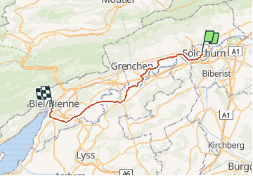
Randonnée Vélo de 32 km à découvrir à Soleure, Bezirk Solothurn, Soleure. Cette randonnée est proposée par LCGsell.

Description

Sechste Strecke der Etappe 010CH07 von Basel nach Biel
Von Solothurn nach Biel geht es flach entlang der Aare und auf der Nationalen Velo Route Nr. 8, der Aare Route. Wie üblich, trifft man auf diesen Familien Routen auf mergelige Feldwege. Wer diese vermeiden will, um leichter voran zu kommen, weicht auf die Strasse auf der Südseite des Flusses aus, Diese verläuft parallel zur Eisenbahn entlang dem Hügelsaum vom Eggberg durch die fünf Dörfer: Lüsslingen, Nennikofen, Leuzingen, Arch und Rüti bis nach Büren an der Aare. Von hier geht es auf dem Damm des Nidau-Büren Kanals nach Biel hinein.
Schnell: 1h30, langsam: 2h

Profil altimétrique

Localisation

Pays :
Suisse
Région :
Soleure
Département/Province :
Bezirk Solothurn
Commune :
Soleure
Localité :
Unknown
Départ:(Dec)
Départ:(UTM)
388893 ; 5229240 (32T) N.

Randonnées à proximité

Randonnée A pied Soleure - Solothurn HB - Derendingen - Photo
A pied
PRO

A pied

Facile
Soleure, Soleure, Bezirk Solothurn, Suisse
4 km | 5,3 km-effort
1h 12min
Non
Randonnée A pied Soleure - Solothurn HB - Lohn Lüterkofen - Photo
A pied
PRO

A pied

Facile
Soleure, Soleure, Bezirk Solothurn, Suisse
5,6 km | 7,5 km-effort
1h 42min
Non
Randonnée A pied Lohn-Ammannsegg - Lohn Lüterkofen - Biberist - Photo
A pied
PRO

A pied

Facile
Lohn-Ammannsegg, Soleure, Bezirk Wasseramt, Suisse
3,8 km | 4,1 km-effort
56min
Non
Randonnée A pied Soleure - Aareuferweg - Photo
A pied
PRO

A pied

Facile
Soleure, Soleure, Bezirk Solothurn, Suisse
4,3 km | 5 km-effort
1h 8min
Non
Randonnée Marche Soleure - wa36 - Photo
Marche
GUIDE+

Marche

Très facile
Soleure, Soleure, Bezirk Solothurn, Suisse
17,7 km | 23 km-effort
7h 33min
Non
Randonnée Marche Rüttenen - Circuit Rüttenen - Soleure 09.10.16 - Photo
Marche
duamerg

Marche

Facile
Rüttenen, Soleure, Bezirk Lebern, Suisse
9,7 km | 12,7 km-effort
2h 44min
Oui
Randonnée Autre activité Oberdorf (SO) - Oberdorf - rocher de Granges - Photo
Autre activité
rebetez

Autre activité

Très facile
Oberdorf (SO), Soleure, Bezirk Lebern, Suisse
18,5 km | 27 km-effort
Inconnu
Non
Randonnée Autre activité Oberdorf (SO) - SO Weissenstein -Grenchenberg - Photo
Autre activité
hrb

Autre activité

Très facile
Oberdorf (SO), Soleure, Bezirk Lebern, Suisse
9,7 km | 16,3 km-effort
Inconnu
Non
Randonnée Marche Oberdorf (SO) - 8 Weissenstein - Frinvillier - Photo
Marche
hallauer

Marche

Très facile
Oberdorf (SO), Soleure, Bezirk Lebern, Suisse
25 km | 37 km-effort
6h 30min
Non


Fermer
Mes abonnements