


274 km | 367 km-effort


Utilisateur


Application GPS de randonnée GRATUITE
 SityTrail
IGN / Instituts géographiques
SityTrail World
Le monde est à vous
Randonnée Vélo de 216 km à découvrir à Bâle-Ville, Inconnu, Bâle. Cette randonnée est proposée par LCGsell.
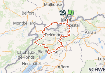
Comment: This is the map and profile of Stage 01 of the Swiss Tour 2007 and the stretches are drawn along lines "as the crow flies". For more details see the description of the respectiv stages and their stretches.
Situation
Basel is situated on the River Rhine and on the northern side of the Jura Mountains which form chains of hills from the Rhine in south-westerly direction towards Geneva. These hills form a natural border between France (Sundgau, French Jura, Franche Comté) and the "rest of Switzerland" on the southern side of the Jura. Biel (German)/ Bienne (French) is on the southern edge of the hills at about 1/3 the distance from Basel to Lake Geneva. The region is part of the cantons Baselland, Solothurn, Aarau, Jura and Bern.
Main Route from Basel to Biel
Train and main road take the direct path along the River Birs, up river, passing Delémont, Moutier to arrive in Reconvelier/ Tavannes by crossing the Jura hills trough the gorges, Gorge de la Birs at Choindez and Gorges de Courts. Across the Col de Pierre Pertuis, 827m or through its tunnel the main route is reaching the River Suze which it follows down river through the Taubenloch gorge to reach Biel and its Lake.
We are describing four routes.
There is a choice of different routes which may be combined freely. All the routes have to cross the Jura Hills and make miles to the west. There a spectacular passes and gorges to cross and roads on crests offer beautiful views to the Alps. Distances and climbs of all the routes can be cut at least in half by using trains which run parallel with our routes.
1. Six Passes Route
123 km, up 2700m, down 2550m
Route 010. From Basel we start right away into the hills and cross the following high points: the Gempen, the Nunnigerberg, the Passwang, the Scheltenpass, the Schmittli to Gänsbrunnen and last but not least the Weissen-stein to Solothurn. The Weissen--stein can also be reached by train and chair lift, bike hooked to the chair. From Solothurn the route follows the Aare river to Biel with no futher climbing or if you still want to do some more climbing you may return into the Jura Hills and ad the Col de Pierre Pertuis to your itinerary. Along the entire route are several points where you may take the train or postal bus to shorten the mileage and go for the best views and downhills.
2. Sundgau and Freiberge
115km, up 2050m, down 1900m
Route 011 is also a challenging and eventful route, so with not as many hills, leading through the nearby French territory, a region called Sundgau, sometimes also called the "Gate to Burgundy". After a visit of the small French provincial town Ferette we cycle back to Switzerland''s "pan" of Porrentruy. If you don''t want to miss the pitoresque St.Ursann at the hairpin of the Doubs river you will have to climb twice to get to Saignelégier. Taking the direct route via Les Rangiers needs one and a softer climb only. Saignelégier is the centre of a high plain with rolling hills, the Freiberge from where you cycle down to Tavannes and across the col Col du Pierre Pertuis ( the romans hammered a hole through the rocks !) to Biel.
3. Direct and short Route
94km, upf 575m, down 410m
Route 012 follows the main traffic roads for cars and train. This almost flatt route can be recommended on sunday mornings when not to many cars are on the way: Basel - Laufen - Delsberg - Moutier - Biel.
4. Across the lowest pass.
105km, up 460m, down 295m
Route 013 draws back to the east via Liestal to reach the low pass Oberer Hauenstein, across which you will get easely to Balstal. There starts the smooth route along the river Aare all the way to Biel. Boats on the river from Solothurn to Biel!
Km 1 to 100: Route 010CH07 Basel - Biel
Km 100 to 200: Route 011CH07 Biel - Basel.

Marche

Vélo

Autre activité
Autre activité
Autre activité
Autre activité
Marche