Randonnée Marche Tingry - tingry - Photo
 JPTABUCHI
JPTABUCHI

Utilisateur

© OpenStreetMap contributors
Longueur
Longueur
20 km
Altitude max
Altitude max
160 m
Dénivelé positif
Dénivelé positif
317 m
Km-Effort
Km-Effort  
25 km
Altitude min
Altitude min
23 m
Dénivelé négatif
Dénivelé négatif
318 m
Boucle
Boucle
Non
Date de création :
2019-05-31 08:00:34.661
Dernière modification :
2019-05-31 08:44:21.267

(0 Avis)

Marche
Marche
43m
Difficulté : Très facile

Scannez ce code QR pour ouvrir la randonnée dans l'application SityTrail

Application GPS de randonnée GRATUITE

Logo SityTrail SityTrail

IGN / Instituts géographiques

Télécharger SityTrail sur l'App Store Télécharger SityTrail sur Google Play

Logo SityTrail SityTrail World

Le monde est à vous

Télécharger SityTrail sur l'App Store Télécharger SityTrail sur Google Play Télécharger SityTrail sur Huawei AppGallery

À propos

Randonnée Marche de 20 km à découvrir à Hauts-de-France, Pas-de-Calais, Tingry. Cette randonnée est proposée par JPTABUCHI.

Description

À la poursuite du lando

Profil altimétrique

Localisation

Pays :
France
Région :
Hauts-de-France
Département/Province :
Pas-de-Calais
Commune :
Tingry
Localité :
Unknown
Départ:(UTM)
408742 ; 5608331 (31U) N.

Randonnées à proximité

Randonnée Marche Nesles - Mont Violette - Nesles - Photo
Marche
tracegps

Marche

Moyen
(1)
Nesles, Hauts-de-France, Pas-de-Calais, France
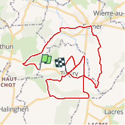
11,6 km | 15,4 km-effort
3h 0min
Oui
Randonnée Marche Samer - Le chemin de Cappe - Samer  - Photo
Marche
tracegps

Marche

Moyen
(1)
Samer, Hauts-de-France, Pas-de-Calais, France
10,7 km | 13,2 km-effort
3h 0min
Oui
Randonnée Marche Hesdigneul-lès-Boulogne - Circuit Sentier du Mont des Prêtres - Hesdigneul les Boulogne - Photo
Marche
tracegps

Marche

Facile
(2)
Hesdigneul-lès-Boulogne, Hauts-de-France, Pas-de-Calais, France
5,2 km | 6,1 km-effort
1h 30min
Oui
Randonnée Marche Samer - Le Mont Corbeau - Samer - Photo
Marche
tracegps

Marche

Difficile
Samer, Hauts-de-France, Pas-de-Calais, France
10,1 km | 12,6 km-effort
3h 0min
Oui
Randonnée V.T.T. Samer - Le Haut Pichot - Samer - Photo
V.T.T.
tracegps

V.T.T.

Difficile
Samer, Hauts-de-France, Pas-de-Calais, France
32 km | 39 km-effort
3h 0min
Oui
Randonnée Marche Samer - Le Haut Pichot - Samer - Photo
Marche
tracegps

Marche

Difficile
Samer, Hauts-de-France, Pas-de-Calais, France
32 km | 39 km-effort
7h 0min
Oui
Randonnée Marche Neufchâtel-Hardelot - De la Glaisière au Vouroux - Photo
Marche
tracegps

Marche

Moyen
(1)
Neufchâtel-Hardelot, Hauts-de-France, Pas-de-Calais, France
15,4 km | 17,7 km-effort
3h 30min
Oui
Randonnée Marche Nesles - Sentier de la Motte Castrale - Nesles - Photo
Marche
tracegps

Marche

Facile
Nesles, Hauts-de-France, Pas-de-Calais, France
2,1 km | 2,8 km-effort
30min
Oui
Randonnée V.T.T. Samer - Le chemin de Cappe - Samer  - Photo
V.T.T.
tracegps

V.T.T.

Moyen
Samer, Hauts-de-France, Pas-de-Calais, France
10,7 km | 13,2 km-effort
1h 30min
Oui


Fermer
Mes abonnements