Randonnée V.T.T. Saint-Étienne-le-Molard - Vers la Loire Naconne Cleppé - Photo
 gannet1
gannet1

Utilisateur

© OpenStreetMap contributors
Longueur
Longueur
30 km
Altitude max
Altitude max
397 m
Dénivelé positif
Dénivelé positif
269 m
Km-Effort
Km-Effort  
33 km
Altitude min
Altitude min
317 m
Dénivelé négatif
Dénivelé négatif
269 m
Boucle
Boucle
Oui
Date de création :
2019-07-16 14:45:20.0
Dernière modification :
2019-07-16 19:04:35.257

(0 Avis)

V.T.T.
V.T.T.
2h36
Difficulté : Facile

Scannez ce code QR pour ouvrir la randonnée dans l'application SityTrail

Application GPS de randonnée GRATUITE

Logo SityTrail SityTrail

IGN / Instituts géographiques

Télécharger SityTrail sur l'App Store Télécharger SityTrail sur Google Play

Logo SityTrail SityTrail World

Le monde est à vous

Télécharger SityTrail sur l'App Store Télécharger SityTrail sur Google Play Télécharger SityTrail sur Huawei AppGallery

À propos

Randonnée V.T.T. de 30 km à découvrir à Auvergne-Rhône-Alpes, Loire, Saint-Étienne-le-Molard. Cette randonnée est proposée par gannet1.

Profil altimétrique

Photos

Points d'intérêt

Point d'intérêt Cleppé - Carrière - Photo
gannet1
CLEPPÉ 

Localisation

Pays :
France
Région :
Auvergne-Rhône-Alpes
Département/Province :
Loire
Commune :
Saint-Étienne-le-Molard
Localité :
Unknown
Départ:(Dec)
Départ:(UTM)
584639 ; 5064939 (31T) N.

Randonnées à proximité

Randonnée Marche Marcilly-le-Châtel - Marcillyvers Goutteras - Photo
Marche
gannet1

Marche

Facile
(2)
Marcilly-le-Châtel, Auvergne-Rhône-Alpes, Loire, France
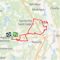
11,1 km | 15,7 km-effort
3h 25min
Oui
Randonnée Marche Saint-Étienne-le-Molard - St Etienne le Molard Montverdun - Photo
Marche
gannet1

Marche

Facile
(1)
Saint-Étienne-le-Molard, Auvergne-Rhône-Alpes, Loire, France
11,6 km | 13,1 km-effort
2h 53min
Non
Randonnée Marche Montverdun - Randonnée autour de Montverdun - Photo
Marche
dudu42

Marche

Facile
Montverdun, Auvergne-Rhône-Alpes, Loire, France
15,7 km | 17,6 km-effort
2h 59min
Oui
Randonnée V.T.T. Arthun - Contreforts du Forez et Réserve de Biterne - Arthun - Photo
V.T.T.
tracegps

V.T.T.

Difficile
Arthun, Auvergne-Rhône-Alpes, Loire, France
35 km | 44 km-effort
3h 15min
Oui
Randonnée Marche Arthun - ARTHUN    - Photo
Marche
nono42

Marche

Difficile
Arthun, Auvergne-Rhône-Alpes, Loire, France
12,1 km | 13,9 km-effort
3h 8min
Oui
Randonnée 4x4 Saint-Étienne-le-Molard - Tour monts Forez - Photo
4x4
gannet1

4x4

Saint-Étienne-le-Molard, Auvergne-Rhône-Alpes, Loire, France
155 km | 0 m-effort
4h 9min
Oui
Randonnée V.T.C. Mornand-en-Forez - VTC Plaine du Forez - Photo
V.T.C.
cyclopat42600

V.T.C.

Très facile
Mornand-en-Forez, Auvergne-Rhône-Alpes, Loire, France
15,4 km | 16,6 km-effort
Inconnu
Oui
Randonnée Marche Saint-Étienne-le-Molard - la guilloche - Photo
Marche
gannet1

Marche

Facile
Saint-Étienne-le-Molard, Auvergne-Rhône-Alpes, Loire, France
12,5 km | 13,6 km-effort
2h 55min
Oui
Randonnée Marche Arthun - Autour d'Arthun - Photo
Marche
gannet1

Marche

Facile
Arthun, Auvergne-Rhône-Alpes, Loire, France
9,8 km | 11,4 km-effort
2h 30min
Oui


Fermer
Mes abonnements