Randonnée Marche Thieulloy-l'Abbaye - Thieulloy - Photo
 dedehenry
dedehenry

Utilisateur

© OpenStreetMap contributors
Longueur
Longueur
13,1 km
Altitude max
Altitude max
179 m
Dénivelé positif
Dénivelé positif
106 m
Km-Effort
Km-Effort  
14,6 km
Altitude min
Altitude min
148 m
Dénivelé négatif
Dénivelé négatif
106 m
Boucle
Boucle
Oui
Date de création :
2019-08-17 13:32:48.0
Dernière modification :
2019-08-17 14:36:23.033

(0 Avis)

Marche
Marche
1h03
Difficulté : Inconnu

Scannez ce code QR pour ouvrir la randonnée dans l'application SityTrail

Application GPS de randonnée GRATUITE

Logo SityTrail SityTrail

IGN / Instituts géographiques

Télécharger SityTrail sur l'App Store Télécharger SityTrail sur Google Play

Logo SityTrail SityTrail World

Le monde est à vous

Télécharger SityTrail sur l'App Store Télécharger SityTrail sur Google Play Télécharger SityTrail sur Huawei AppGallery

À propos

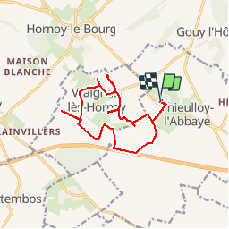
Randonnée Marche de 13,1 km à découvrir à Hauts-de-France, Somme, Thieulloy-l'Abbaye. Cette randonnée est proposée par dedehenry.

Profil altimétrique

Localisation

Pays :
France
Région :
Hauts-de-France
Département/Province :
Somme
Commune :
Thieulloy-l'Abbaye
Localité :
Unknown
Départ:(Dec)
Départ:(UTM)
423415 ; 5520031 (31U) N.

Randonnées à proximité

Randonnée Vélo Hornoy-le-Bourg - La Chaise - Hornoy le Bourg - Belloy Saint Léonard - Photo
Vélo
tracegps

Vélo

Difficile
Hornoy-le-Bourg, Hauts-de-France, Somme, France
21 km | 25 km-effort
1h 30min
Oui
Randonnée Vélo Hornoy-le-Bourg - La Chaise - Hornoy le Bourg - Neuville Coppegueule - Photo
Vélo
tracegps

Vélo

Difficile
Hornoy-le-Bourg, Hauts-de-France, Somme, France
37 km | 44 km-effort
2h 0min
Oui
Randonnée V.T.T. Saint-Aubin-Montenoy - Oissy Briquemesnil St Aubin - Photo
V.T.T.
sebcar

V.T.T.

Très facile
Saint-Aubin-Montenoy, Hauts-de-France, Somme, France
32 km | 37 km-effort
2h 34min
Oui
Randonnée V.T.T. Saint-Aubin-Montenoy - saint Aubin aumont - Photo
V.T.T.
sebcar

V.T.T.

Moyen
Saint-Aubin-Montenoy, Hauts-de-France, Somme, France
27 km | 33 km-effort
2h 10min
Oui
Randonnée V.T.T. Saint-Aubin-Montenoy - Saint Aubin montenoy - Photo
V.T.T.
sebcar

V.T.T.

Facile
Saint-Aubin-Montenoy, Hauts-de-France, Somme, France
15,5 km | 18,6 km-effort
1h 0min
Oui


Fermer
Mes abonnements