Randonnée Marche Comines-Warneton - Ploegsteert  - Photo
 Laurent_df
Laurent_df

Utilisateur

© OpenStreetMap contributors
Longueur
Longueur
4,6 km
Altitude max
Altitude max
58 m
Dénivelé positif
Dénivelé positif
65 m
Km-Effort
Km-Effort  
5,4 km
Altitude min
Altitude min
16 m
Dénivelé négatif
Dénivelé négatif
53 m
Boucle
Boucle
Non
Date de création :
2019-08-25 12:07:32.18
Dernière modification :
2019-08-25 13:45:11.769

(0 Avis)

Marche
Marche
1h34
Difficulté : Facile

Scannez ce code QR pour ouvrir la randonnée dans l'application SityTrail

Application GPS de randonnée GRATUITE

Logo SityTrail SityTrail

IGN / Instituts géographiques

Télécharger SityTrail sur l'App Store Télécharger SityTrail sur Google Play

Logo SityTrail SityTrail World

Le monde est à vous

Télécharger SityTrail sur l'App Store Télécharger SityTrail sur Google Play Télécharger SityTrail sur Huawei AppGallery

À propos

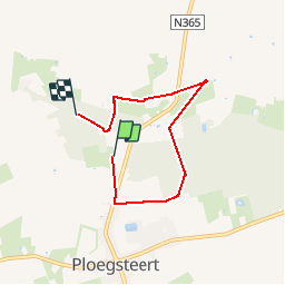
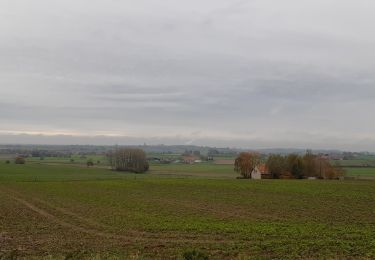
Randonnée Marche de 4,6 km à découvrir à Wallonie, Hainaut, Comines-Warneton. Cette randonnée est proposée par Laurent_df.

Profil altimétrique

Localisation

Pays :
Belgique
Région :
Wallonie
Département/Province :
Hainaut
Commune :
Comines-Warneton
Localité :
Ploegsteert
Départ:(UTM)
491545 ; 5620564 (31U) N.

Randonnées à proximité

Randonnée A pied Heuvelland - Geuzen wandelroute - Photo
A pied
PRO

A pied

Facile
Heuvelland, Flandre, Flandre-Occidentale, Belgique
9,7 km | 11,4 km-effort
2h 35min
Oui
Randonnée Marche Frelinghien - Frelinghien 10,9 km - Photo
Marche
GUIDE
rvapeldo

Marche

Moyen
Frelinghien, Hauts-de-France, Nord, France
10,9 km | 11,7 km-effort
2h 56min
Oui
Randonnée Marche Frelinghien - Frelinghien Deule 13 km - Photo
Marche
GUIDE
rvapeldo

Marche

Facile
Frelinghien, Hauts-de-France, Nord, France
13,2 km | 14 km-effort
4h 3min
Oui
Randonnée Marche Heuvelland - Nieuwekerke Bailleul 17,5 km - Photo
Marche
GUIDE
rvapeldo

Marche

Moyen
Heuvelland, Flandre, Flandre-Occidentale, Belgique
18,7 km | 21 km-effort
4h 53min
Oui
Randonnée V.T.T. Armentières - La Lys du plat pays entre Serpentine et Warnave - Armentières - Photo
V.T.T.
tracegps

V.T.T.

Moyen
Armentières, Hauts-de-France, Nord, France
37 km | 40 km-effort
3h 0min
Oui
Randonnée V.T.T. Frelinghien - A l ombre de la cathédrale de la Lys - Frelinghien - Photo
V.T.T.
tracegps

V.T.T.

Moyen
Frelinghien, Hauts-de-France, Nord, France
13,8 km | 14,8 km-effort
1h 19min
Oui
Randonnée Marche Frelinghien - A l ombre de la cathédrale de la Lys - Frelinghien - Photo
Marche
tracegps

Marche

Difficile
(1)
Frelinghien, Hauts-de-France, Nord, France
13,8 km | 14,8 km-effort
3h 30min
Oui
Randonnée Marche Nieppe - De Nieppe à la Lys - Photo
Marche
tracegps

Marche

Facile
Nieppe, Hauts-de-France, Nord, France
8,2 km | 8,6 km-effort
2h 0min
Oui
Randonnée Marche Comines-Warneton - Ploegsteert-Messines - Photo
Marche
Greg813

Marche

Très difficile
Comines-Warneton, Wallonie, Hainaut, Belgique
24 km | 27 km-effort
6h 3min
Oui


Fermer
Mes abonnements