


Marche TL 09/19 Col du Boenlesgrab - FA Buchwald

patrickbeyrath
Utilisateur
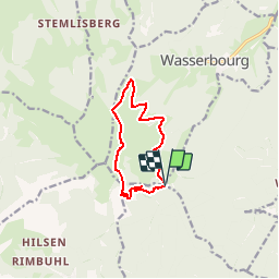

Longueur
9,4 km

Altitude max
1154 m

Dénivelé positif
407 m
Km-Effort
14,8 km

Altitude min
834 m

Dénivelé négatif
401 m
Boucle
Oui
Date de création :
2019-08-30 05:09:32.163
Dernière modification :
2019-09-10 05:47:07.697
--
Difficulté : Moyen

Application GPS de randonnée GRATUITE
 SityTrail
IGN / Instituts géographiques
SityTrail Plus
Le monde est à vous
À propos
Randonnée Marche de 9,4 km à découvrir à Grand Est, Haut-Rhin, Wasserbourg. Cette randonnée est proposée par patrickbeyrath.
Description
Col du Boenlesgrab - Kaltenbrunnen - Drei Schoepf - Wasenmatten - Buchwald - Strohberg - Schellimatt et retour
Localisation
Pays :
France
Région :
Grand Est
Département/Province :
Haut-Rhin
Commune :
Wasserbourg
Localité :
Unknown
Départ:(Dec)
Départ:(UTM)
361786 ; 5315349 (32T) N.
Commentaires