Randonnée Marche Mont-Albert - Mont Albert - Parc national de la Gaspésie  - Photo

Mont Albert - Parc national de la Gaspésie

 Alizée.pee
Alizée.pee

Utilisateur GUIDE

© OpenStreetMap contributors
Longueur
Longueur
16,8 km
Altitude max
Altitude max
1061 m
Dénivelé positif
Dénivelé positif
891 m
Km-Effort
Km-Effort  
29 km
Altitude min
Altitude min
207 m
Dénivelé négatif
Dénivelé négatif
891 m
Boucle
Boucle
Oui
Date de création :
2019-09-03 10:40:41.037
Dernière modification :
2019-09-03 10:45:06.266

(0 Avis)

Marche
Marche
7h00
Difficulté : Très difficile

Scannez ce code QR pour ouvrir la randonnée dans l'application SityTrail

Application GPS de randonnée GRATUITE

Logo SityTrail SityTrail

IGN / Instituts géographiques

Télécharger SityTrail sur l'App Store Télécharger SityTrail sur Google Play

Logo SityTrail SityTrail World

Le monde est à vous

Télécharger SityTrail sur l'App Store Télécharger SityTrail sur Google Play Télécharger SityTrail sur Huawei AppGallery

À propos

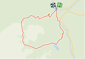
Randonnée Marche de 16,8 km à découvrir à Québec, La Haute-Gaspésie, Mont-Albert. Cette randonnée est proposée par Alizée.pee.

Description

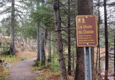
Ce mont fait partie des magnifiques mont Chics-Chocs se situant dans le parc national de la Gaspésie. Le sommet de ce ont est assez connu car c’est en réalité un immense plateau. De là, de magnifiques vues s’offrent à vous. Du sommet, possibilité de descendre vers la vallée du Diable en longeant un ruisseau ou simplement de retourner sur vos pas pour rejoindre le début de la randonnée. Néanmoins, la plus belle partie de cette randonnée est le sentier de la Vallée, à ne pas manquer ! Balada assez difficile et longue mais qui en vaut la peine !

Profil altimétrique

Points d'intérêt

Point d'intérêt Mont-Albert - Sommet - Mont Olivine - Photo
Alizée.pee
Point d'intérêt Mont-Albert - Sommet - Mont Albert - Photo
Alizée.pee
Point d'intérêt Mont-Albert - Intersection 4 - Photo
Alizée.pee
MONT-ALBERT 
Point d'intérêt Mont-Albert - Intersection 3 - Photo
Alizée.pee
MONT-ALBERT 
Point d'intérêt Mont-Albert - Intersection 2 - Photo
Alizée.pee
MONT-ALBERT 
Point d'intérêt Mont-Albert - Intersection 1 - Photo
Alizée.pee
MONT-ALBERT 
Point d'intérêt Mont-Albert - Début du sentier - Photo
Alizée.pee
MONT-ALBERT 
Point d'intérêt Mont-Albert - Chute Sainte-Anne - Photo
Alizée.pee
MONT-ALBERT 
Point d'intérêt Mont-Albert - Chute du Diable - Photo
Alizée.pee
MONT-ALBERT 
Point d'intérêt Mont-Albert - Belvédère de la Saillie - Photo
Alizée.pee
Point d'intérêt Mont-Albert - Abri de la Serpentine - Photo
Alizée.pee

Localisation

Pays :
Canada
Région :
Québec
Département/Province :
La Haute-Gaspésie
Commune :
Mont-Albert
Localité :
Unknown
Départ:(UTM)
710585 ; 5425523 (19U) N.

Randonnées à proximité

Randonnée Marche Mont-Albert - Mont Ernest-Laforce  - Photo
Marche
GUIDE
Alizée.pee

Marche

Facile
(1)
Mont-Albert, Québec, La Haute-Gaspésie, Canada
4,5 km | 7 km-effort
1h 50min
Oui
Randonnée Marche Mont-Albert - Chutes du diable - sentier du Mont Albert - Photo
Marche
ajpbm

Marche

Moyen
Mont-Albert, Québec, La Haute-Gaspésie, Canada
6,9 km | 8,6 km-effort
1h 48min
Oui
Randonnée Marche Mont-Albert - Mont Olivine et Abri de la Serpentine - Photo
Marche
GUIDE
Alizée.pee

Marche

Très difficile
Mont-Albert, Québec, La Haute-Gaspésie, Canada
17 km | 26 km-effort
5h 19min
Oui
Randonnée Marche Mont-Albert - Chute du diable - Photo
Marche
GUIDE
Alizée.pee

Marche

Moyen
Mont-Albert, Québec, La Haute-Gaspésie, Canada
7,1 km | 9,1 km-effort
1h 56min
Oui
Randonnée Marche Mont-Albert - Parc National de la Gaspésie - Mont Ernest Laforce - Photo
Marche
GUIDE
Alizée.pee

Marche

Moyen
Mont-Albert, Québec, La Haute-Gaspésie, Canada
5,5 km | 8,6 km-effort
1h 46min
Oui
Randonnée Marche Mont-Albert - Parc National de la Gaspesie -Tour du Mont Albert - Photo
Marche
GUIDE
Alizée.pee

Marche

Très difficile
Mont-Albert, Québec, La Haute-Gaspésie, Canada
17 km | 29 km-effort
5h 53min
Oui
Randonnée Marche Mont-Albert - Tour du mont Ernest Laforce - Photo
Marche
s0c7

Marche

Très facile
Mont-Albert, Québec, La Haute-Gaspésie, Canada
7,8 km | 11,1 km-effort
1h 15min
Non
Randonnée Marche Mont-Albert - Mont Albert - Photo
Marche
aldaus

Marche

Moyen
Mont-Albert, Québec, La Haute-Gaspésie, Canada
13,5 km | 25 km-effort
3h 43min
Oui
Randonnée Marche Mont-Albert - mont Ernest Laforce  - Photo
Marche
s0c7

Marche

Facile
Mont-Albert, Québec, La Haute-Gaspésie, Canada
4,8 km | 7,3 km-effort
1h 30min
Oui


Fermer
Mes abonnements