


RS-Thodure-Le Rival

raymondfn
Utilisateur
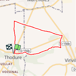

Longueur
6,8 km

Altitude max
373 m

Dénivelé positif
93 m
Km-Effort
8 km

Altitude min
298 m

Dénivelé négatif
93 m
Boucle
Oui
Date de création :
2019-10-03 12:16:23.095
Dernière modification :
2019-10-03 12:25:21.625
1h45
Difficulté : Moyen

Application GPS de randonnée GRATUITE
 SityTrail
IGN / Instituts géographiques
SityTrail Plus
Le monde est à vous
À propos
Randonnée Marche de 6,8 km à découvrir à Auvergne-Rhône-Alpes, Isère, Thodure. Cette randonnée est proposée par raymondfn.
Description
Rando Santé
Localisation
Pays :
France
Région :
Auvergne-Rhône-Alpes
Département/Province :
Isère
Commune :
Thodure
Localité :
Unknown
Départ:(Dec)
Départ:(UTM)
670015 ; 5020549 (31T) N.
Commentaires