


Forêt de Deville

sameja
Utilisateur
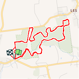

Longueur
14 km

Altitude max
41 m

Dénivelé positif
144 m
Km-Effort
15,9 km

Altitude min
8 m

Dénivelé négatif
143 m
Boucle
Oui
Date de création :
2019-10-17 15:38:40.0
Dernière modification :
2019-10-17 17:53:34.364
2h14
Difficulté : Difficile

Application GPS de randonnée GRATUITE
 SityTrail
IGN / Instituts géographiques
SityTrail Plus
Le monde est à vous
À propos
Randonnée Trail de 14 km à découvrir à Guadeloupe, Inconnu, Petit-Canal. Cette randonnée est proposée par sameja.
Description
Petit canal la boucle
Localisation
Pays :
France
Région :
Guadeloupe
Département/Province :
Inconnu
Commune :
Petit-Canal
Localité :
Unknown
Départ:(Dec)
Départ:(UTM)
662450 ; 1811317 (20Q) N.
Commentaires