Randonnée Marche Charmes-la-Côte - Circuit saint -Fiacre - Photo
 Samuel88300
Samuel88300

Utilisateur

© OpenStreetMap contributors
Longueur
Longueur
11 km
Altitude max
Altitude max
411 m
Dénivelé positif
Dénivelé positif
244 m
Km-Effort
Km-Effort  
14,3 km
Altitude min
Altitude min
268 m
Dénivelé négatif
Dénivelé négatif
256 m
Boucle
Boucle
Oui
Date de création :
2019-10-20 11:35:28.0
Dernière modification :
2019-10-20 14:50:07.553

(0 Avis)

Marche
Marche
2h59
Difficulté : Inconnu

Scannez ce code QR pour ouvrir la randonnée dans l'application SityTrail

Application GPS de randonnée GRATUITE

Logo SityTrail SityTrail

IGN / Instituts géographiques

Télécharger SityTrail sur l'App Store Télécharger SityTrail sur Google Play

Logo SityTrail SityTrail World

Le monde est à vous

Télécharger SityTrail sur l'App Store Télécharger SityTrail sur Google Play Télécharger SityTrail sur Huawei AppGallery

À propos

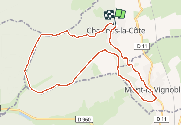
Randonnée Marche de 11 km à découvrir à Grand Est, Meurthe-et-Moselle, Charmes-la-Côte. Cette randonnée est proposée par Samuel88300.

Description

Petite randonnée facile entre vignes et forêt et

Profil altimétrique

Localisation

Pays :
France
Région :
Grand Est
Département/Province :
Meurthe-et-Moselle
Commune :
Charmes-la-Côte
Localité :
Unknown
Départ:(Dec)
Départ:(UTM)
708372 ; 5389903 (31U) N.

Randonnées à proximité

Randonnée V.T.T. Toul - Côtes de Toul 50k 2012 - Photo
V.T.T.
virginieHurpeau

V.T.T.

Difficile
(2)
Toul, Grand Est, Meurthe-et-Moselle, France
59 km | 75 km-effort
5h 15min
Oui
Randonnée A pied Choloy-Ménillot - Boucle des Sources - Photo
A pied
PRO

A pied

Facile
Choloy-Ménillot, Grand Est, Meurthe-et-Moselle, France
10,4 km | 11,9 km-effort
2h 42min
Non
Randonnée Marche Choloy-Ménillot - Cholloy-Ménillot 14 150m +335m - Photo
Marche
DanielROLLET

Marche

Difficile
Choloy-Ménillot, Grand Est, Meurthe-et-Moselle, France
14,2 km | 18,6 km-effort
3h 30min
Oui
Randonnée Marche Rigny-Saint-Martin - st fiacre-choloy - Photo
Marche
mannequ1

Marche

Moyen
Rigny-Saint-Martin, Grand Est, Meuse, France
18,6 km | 23 km-effort
3h 56min
Oui
Randonnée Marche nordique Domgermain - Marche au palteau de Domgermain - Photo
Marche nordique
SANTINI

Marche nordique

Facile
Domgermain, Grand Est, Meurthe-et-Moselle, France
8,6 km | 10,1 km-effort
1h 29min
Oui
Randonnée Marche Blénod-lès-Toul - rando 12km vers Bulligny - Photo
Marche
sandra54570

Marche

Difficile
Blénod-lès-Toul, Grand Est, Meurthe-et-Moselle, France
11,9 km | 15,6 km-effort
1h 36min
Oui
Randonnée Marche Choloy-Ménillot - Choloy-Ménillot 13 388m +323m - Photo
Marche
DanielROLLET

Marche

Difficile
Choloy-Ménillot, Grand Est, Meurthe-et-Moselle, France
13,9 km | 18,2 km-effort
4h 7min
Oui
Randonnée Marche Foug - Choloy-Ménillot 11 360m +227m - Photo
Marche
DanielROLLET

Marche

Difficile
Foug, Grand Est, Meurthe-et-Moselle, France
11,4 km | 14,4 km-effort
3h 16min
Oui
Randonnée Marche Moutrot - moutrot nuit - Photo
Marche
ardou5455

Marche

Difficile
Moutrot, Grand Est, Meurthe-et-Moselle, France
13,7 km | 16,2 km-effort
2h 33min
Oui


Fermer
Mes abonnements