Randonnée Marche Lieudieu - lieudieu - Photo
 ronomarlybin
ronomarlybin

Utilisateur

© OpenStreetMap contributors
Longueur
Longueur
8,3 km
Altitude max
Altitude max
524 m
Dénivelé positif
Dénivelé positif
176 m
Km-Effort
Km-Effort  
10,7 km
Altitude min
Altitude min
461 m
Dénivelé négatif
Dénivelé négatif
187 m
Boucle
Boucle
Non
Date de création :
2019-11-05 09:49:24.877
Dernière modification :
2019-11-05 14:53:33.524

(1 Avis)

Marche
Marche
3h25
Difficulté : Très facile

Scannez ce code QR pour ouvrir la randonnée dans l'application SityTrail

Application GPS de randonnée GRATUITE

Logo SityTrail SityTrail

IGN / Instituts géographiques

Télécharger SityTrail sur l'App Store Télécharger SityTrail sur Google Play

Logo SityTrail SityTrail World

Le monde est à vous

Télécharger SityTrail sur l'App Store Télécharger SityTrail sur Google Play Télécharger SityTrail sur Huawei AppGallery

À propos

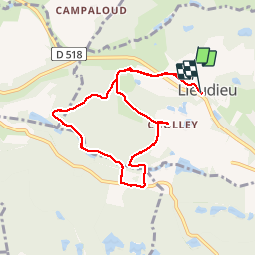
Randonnée Marche de 8,3 km à découvrir à Auvergne-Rhône-Alpes, Isère, Lieudieu. Cette randonnée est proposée par ronomarlybin.

Description

rando des châtaignes. beaucoup châtaigniers.  rando sous-bois.

Profil altimétrique

Localisation

Pays :
France
Région :
Auvergne-Rhône-Alpes
Département/Province :
Isère
Commune :
Lieudieu
Localité :
Unknown
Départ:(UTM)
670422 ; 5036318 (31T) N.

Commentaires

Veuillez vous connecter pour laisser un commentaire ou une note


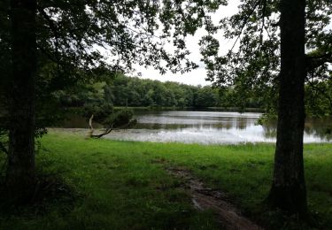
Cette balade traverse des roncier sur 30% de son parcours. Mieux vaut éviter si on n'a pas de coupe-coupe !


Randonnées à proximité

Randonnée Marche Porte-des-Bonnevaux - 38-arzay-Bonnevaux-22km-220m-aout21 - Photo
Marche
SyMA

Marche

Moyen
Porte-des-Bonnevaux, Auvergne-Rhône-Alpes, Isère, France
22 km | 25 km-effort
5h 16min
Oui
Randonnée Marche Châtonnay - chatonnay - Photo
Marche
lilloue

Marche

Très difficile
Châtonnay, Auvergne-Rhône-Alpes, Isère, France
14,9 km | 19,4 km-effort
4h 58min
Oui
Randonnée V.T.T. Saint-Jean-de-Bournay - Essai  - Photo
V.T.T.
Jocelyn Derville

V.T.T.

Moyen
Saint-Jean-de-Bournay, Auvergne-Rhône-Alpes, Isère, France
18,7 km | 22 km-effort
1h 20min
Oui
Randonnée Marche Saint-Jean-de-Bournay - 1/07 - Photo
Marche
GALIBER

Marche

Très facile
Saint-Jean-de-Bournay, Auvergne-Rhône-Alpes, Isère, France
5,1 km | 7,6 km-effort
1h 39min
Non
Randonnée Marche Bossieu - Bossieu - Photo
Marche
beckerse

Marche

Facile
Bossieu, Auvergne-Rhône-Alpes, Isère, France
8,8 km | 10,7 km-effort
2h 19min
Oui
Randonnée Marche Saint-Jean-de-Bournay - Chapelle St Hugon - Photo
Marche
yvos38

Marche

Très facile
Saint-Jean-de-Bournay, Auvergne-Rhône-Alpes, Isère, France
3,8 km | 4,8 km-effort
1h 2min
Oui
Randonnée Marche Châtonnay - chatonnay bis - Photo
Marche
bone52

Marche

Très facile
Châtonnay, Auvergne-Rhône-Alpes, Isère, France
13 km | 16,2 km-effort
2h 21min
Oui
Randonnée Marche Bossieu - bossieu - Photo
Marche
SuperGillou

Marche

Moyen
Bossieu, Auvergne-Rhône-Alpes, Isère, France
10,3 km | 12,7 km-effort
2h 36min
Oui
Randonnée Marche Bossieu - Forêt de Bonnevaux - Photo
Marche
Vedett26

Marche

Moyen
Bossieu, Auvergne-Rhône-Alpes, Isère, France
9,4 km | 10,7 km-effort
2h 26min
Oui


Fermer
Mes abonnements