Randonnée A pied Normanville - normanville - Photo
 bipf
bipf

Utilisateur

© OpenStreetMap contributors
Longueur
Longueur
9,1 km
Altitude max
Altitude max
154 m
Dénivelé positif
Dénivelé positif
134 m
Km-Effort
Km-Effort  
10,9 km
Altitude min
Altitude min
47 m
Dénivelé négatif
Dénivelé négatif
136 m
Boucle
Boucle
Oui
Date de création :
2019-12-02 13:05:19.484
Dernière modification :
2019-12-05 13:28:27.728

(0 Avis)

A pied
A pied
--
Difficulté : Très facile

Scannez ce code QR pour ouvrir la randonnée dans l'application SityTrail

Application GPS de randonnée GRATUITE

Logo SityTrail SityTrail

IGN / Instituts géographiques

Télécharger SityTrail sur l'App Store Télécharger SityTrail sur Google Play

Logo SityTrail SityTrail World

Le monde est à vous

Télécharger SityTrail sur l'App Store Télécharger SityTrail sur Google Play Télécharger SityTrail sur Huawei AppGallery

À propos

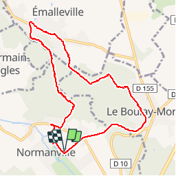
Randonnée A pied de 9,1 km à découvrir à Normandie, Eure, Normanville. Cette randonnée est proposée par bipf.

Description

Belle randonnée de 9km au départ du parking du stade -( allée du château ).
A voir : L'ancienne poterne ( Allée du château )
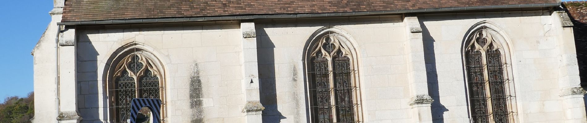
L'église St-Gaud et son cadran solaire
Le château d'Emalleville
Et si vous avez de la chance, une harde de cerf et biches dans le parc du château du Boulay- Morin en redescendant vers Normanville.

Profil altimétrique

Photos

Localisation

Pays :
France
Région :
Normandie
Département/Province :
Eure
Commune :
Normanville
Localité :
Unknown
Départ:(UTM)
365552 ; 5437567 (31U) N.

Randonnées à proximité

Randonnée Marche Huest - les trois etangs - Photo
Marche
bernard.bonafous@free.fr

Marche

Très difficile
(1)
Huest, Normandie, Eure, France
25 km | 28 km-effort
6h 25min
Oui
Randonnée Marche Tourneville - autrebocs - Photo
Marche
papytonvelo

Marche

Très facile
(1)
Tourneville, Normandie, Eure, France
11,7 km | 14,7 km-effort
3h 26min
Non
Randonnée Marche Gravigny - La Maladrerie (Gravigny) - Photo
Marche
douneto

Marche

Facile
Gravigny, Normandie, Eure, France
5,5 km | 6,5 km-effort
1h 30min
Oui
Randonnée Marche Sacquenville - Autrebosc Brosville - Photo
Marche
Ericbougourd

Marche

Très facile
(1)
Sacquenville, Normandie, Eure, France
9,1 km | 11,4 km-effort
1h 30min
Non
Randonnée Marche Normanville - Circuit de Normanville - Photo
Marche
tiberiu

Marche

Moyen
(4)
Normanville, Normandie, Eure, France
13 km | 16,5 km-effort
4h 26min
Oui
Randonnée V.T.T. Gravigny - Balade dans la vallée d'iton - Photo
V.T.T.
tracegps

V.T.T.

Très difficile
Gravigny, Normandie, Eure, France
63 km | 80 km-effort
3h 15min
Oui
Randonnée V.T.T. Gravigny - Chemins et collines entre les deux vallées - Gravigny - Photo
V.T.T.
tracegps

V.T.T.

Difficile
Gravigny, Normandie, Eure, France
49 km | 58 km-effort
2h 40min
Oui
Randonnée V.T.T. Gravigny - Forêts et plaines autour de Gravigny - Photo
V.T.T.
tracegps

V.T.T.

Difficile
Gravigny, Normandie, Eure, France
42 km | 48 km-effort
2h 30min
Oui
Randonnée V.T.T. Brosville - Autour de Brosville - Photo
V.T.T.
tracegps

V.T.T.

Difficile
Brosville, Normandie, Eure, France
32 km | 39 km-effort
3h 0min
Oui


Fermer
Mes abonnements