Randonnée V.T.T. Ajat -  - Photo
 phil24
phil24

Utilisateur

© OpenStreetMap contributors
Longueur
Longueur
16,4 km
Altitude max
Altitude max
286 m
Dénivelé positif
Dénivelé positif
239 m
Km-Effort
Km-Effort  
19,6 km
Altitude min
Altitude min
193 m
Dénivelé négatif
Dénivelé négatif
239 m
Boucle
Boucle
Oui
Date de création :
2019-04-25 06:39:03.965
Dernière modification :
2019-04-25 06:39:04.04

(0 Avis)

V.T.T.
V.T.T.
1h17
Difficulté : Facile

Scannez ce code QR pour ouvrir la randonnée dans l'application SityTrail

Application GPS de randonnée GRATUITE

Logo SityTrail SityTrail

IGN / Instituts géographiques

Télécharger SityTrail sur l'App Store Télécharger SityTrail sur Google Play

Logo SityTrail SityTrail World

Le monde est à vous

Télécharger SityTrail sur l'App Store Télécharger SityTrail sur Google Play Télécharger SityTrail sur Huawei AppGallery

À propos

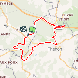
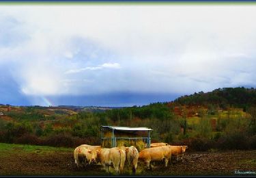
Randonnée V.T.T. de 16,4 km à découvrir à Nouvelle-Aquitaine, Dordogne, Ajat. Cette randonnée est proposée par phil24.

Profil altimétrique

Photos

Points d'intérêt

Point d'intérêt Thenon - borie Point 2 - Photo
phil24

Localisation

Pays :
France
Région :
Nouvelle-Aquitaine
Département/Province :
Dordogne
Commune :
Ajat
Localité :
Unknown
Départ:(Dec)
Départ:(UTM)
345877 ; 5001168 (31T) N.

Randonnées à proximité

Randonnée Marche Limeyrat - limeyrat - Photo
Marche
fab0202

Marche

Facile
Limeyrat, Nouvelle-Aquitaine, Dordogne, France
11,1 km | 13,3 km-effort
2h 48min
Oui
Randonnée V.T.T. Ajat - reco 3 romain thenon - Photo
V.T.T.
phil24

V.T.T.

Facile
Ajat, Nouvelle-Aquitaine, Dordogne, France
19,1 km | 23 km-effort
2h 3min
Oui
Randonnée V.T.T. Ajat - reco 3 romain thenon - Photo
V.T.T.
phil24

V.T.T.

Facile
Ajat, Nouvelle-Aquitaine, Dordogne, France
19,1 km | 23 km-effort
2h 3min
Oui
Randonnée V.T.T. Thenon - Du Verdoyant à Saint Léon-sur-Vézère - Photo
V.T.T.
tracegps

V.T.T.

Difficile
Thenon, Nouvelle-Aquitaine, Dordogne, France
30 km | 40 km-effort
3h 0min
Non
Randonnée V.T.T. Thenon - Du Verdoyant à St Orse avec la boucle du Boscornut -  Thenon - Photo
V.T.T.
tracegps

V.T.T.

Difficile
Thenon, Nouvelle-Aquitaine, Dordogne, France
35 km | 46 km-effort
3h 0min
Non
Randonnée V.T.T. Thenon - Au départ du Verdoyant - Thenon - Photo
V.T.T.
tracegps

V.T.T.

Difficile
Thenon, Nouvelle-Aquitaine, Dordogne, France
34 km | 45 km-effort
3h 0min
Oui
Randonnée V.T.T. Thenon - Sortie Thenon - Photo
V.T.T.
guycouderc

V.T.T.

Moyen
Thenon, Nouvelle-Aquitaine, Dordogne, France
25 km | 30 km-effort
1h 59min
Oui
Randonnée Marche Ajat - Beauzens Rozas La Rolfie 12km - Photo
Marche
YV24

Marche

Facile
Ajat, Nouvelle-Aquitaine, Dordogne, France
11,7 km | 14,3 km-effort
2h 54min
Oui
Randonnée Marche Ajat - Bauzens Patrimoine - Photo
Marche
NICOLEROBERT

Marche

Très facile
Ajat, Nouvelle-Aquitaine, Dordogne, France
10,4 km | 13 km-effort
3h 3min
Oui


Fermer
Mes abonnements