Randonnée Course à pied Layrac - footing trail - Photo
 wardom
wardom

Utilisateur

© OpenStreetMap contributors
Longueur
Longueur
64 km
Altitude max
Altitude max
216 m
Dénivelé positif
Dénivelé positif
1417 m
Km-Effort
Km-Effort  
82 km
Altitude min
Altitude min
41 m
Dénivelé négatif
Dénivelé négatif
1267 m
Boucle
Boucle
Non
Date de création :
2019-12-14 22:33:52.459
Dernière modification :
2019-12-15 18:30:01.898

(0 Avis)

Course à pied
Course à pied
3h06
Difficulté : Très facile

Scannez ce code QR pour ouvrir la randonnée dans l'application SityTrail

Application GPS de randonnée GRATUITE

Logo SityTrail SityTrail

IGN / Instituts géographiques

Télécharger SityTrail sur l'App Store Télécharger SityTrail sur Google Play

Logo SityTrail SityTrail World

Le monde est à vous

Télécharger SityTrail sur l'App Store Télécharger SityTrail sur Google Play Télécharger SityTrail sur Huawei AppGallery

À propos

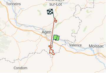
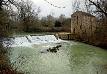
Randonnée Course à pied de 64 km à découvrir à Nouvelle-Aquitaine, Lot-et-Garonne, Layrac. Cette randonnée est proposée par wardom.

Profil altimétrique

Localisation

Pays :
France
Région :
Nouvelle-Aquitaine
Département/Province :
Lot-et-Garonne
Commune :
Layrac
Localité :
Unknown
Départ:(UTM)
313840 ; 4887626 (31T) N.

Randonnées à proximité

Randonnée V.T.T. Sauveterre-Saint-Denis - Sauveterre St Denis - Photo
V.T.T.
tracegps

V.T.T.

Moyen
Sauveterre-Saint-Denis, Nouvelle-Aquitaine, Lot-et-Garonne, France
30 km | 34 km-effort
2h 0min
Oui
Randonnée Marche Sauveterre-Saint-Denis - Sauveterre St Denis - Photo
Marche
tracegps

Marche

Très difficile
Sauveterre-Saint-Denis, Nouvelle-Aquitaine, Lot-et-Garonne, France
30 km | 34 km-effort
6h 0min
Oui
Randonnée Cheval Layrac - Layrac, une randonnée dans la vallée du Gers - Pays de l'Agenais - Photo
Cheval
tracegps

Cheval

Moyen
Layrac, Nouvelle-Aquitaine, Lot-et-Garonne, France
14,2 km | 17,4 km-effort
2h 30min
Oui
Randonnée V.T.T. Layrac - Layrac, une randonnée dans la vallée du Gers - Pays de l'Agenais - Photo
V.T.T.
tracegps

V.T.T.

Moyen
Layrac, Nouvelle-Aquitaine, Lot-et-Garonne, France
14,2 km | 17,4 km-effort
1h 49min
Oui
Randonnée Marche Layrac - Layrac, une randonnée dans la vallée du Gers - Pays de l'Agenais - Photo
Marche
tracegps

Marche

Moyen
(1)
Layrac, Nouvelle-Aquitaine, Lot-et-Garonne, France
14,2 km | 17,4 km-effort
3h 45min
Oui
Randonnée Marche Layrac - Goulens, balade dans les coteaux de Gascogne - Pays de l'Agenais - Photo
Marche
tracegps

Marche

Moyen
Layrac, Nouvelle-Aquitaine, Lot-et-Garonne, France
6,2 km | 7,9 km-effort
1h 40min
Oui
Randonnée Cheval Cuq - Cuq / Fals, un circuit de randonnée en Gascogne - Pays de l'Agenais - Photo
Cheval
tracegps

Cheval

Moyen
Cuq, Nouvelle-Aquitaine, Lot-et-Garonne, France
12,5 km | 16,5 km-effort
2h 10min
Oui
Randonnée V.T.T. Cuq - Cuq / Fals, un circuit de randonnée en Gascogne - Pays de l'Agenais - Photo
V.T.T.
tracegps

V.T.T.

Moyen
Cuq, Nouvelle-Aquitaine, Lot-et-Garonne, France
12,5 km | 16,5 km-effort
1h 40min
Oui
Randonnée Marche Cuq - Cuq / Fals, un circuit de randonnée en Gascogne - Pays de l'Agenais - Photo
Marche
tracegps

Marche

Moyen
Cuq, Nouvelle-Aquitaine, Lot-et-Garonne, France
12,5 km | 16,5 km-effort
3h 15min
Oui


Fermer
Mes abonnements