


RS-Plan-les étangs

raymondfn
Utilisateur
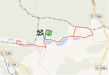

Longueur
4,7 km

Altitude max
512 m

Dénivelé positif
74 m
Km-Effort
5,7 km

Altitude min
471 m

Dénivelé négatif
73 m
Boucle
Oui
Date de création :
2020-01-23 16:21:17.917
Dernière modification :
2020-01-25 08:40:30.306
36m
Difficulté : Facile

Application GPS de randonnée GRATUITE
 SityTrail
IGN / Instituts géographiques
SityTrail Plus
Le monde est à vous
À propos
Randonnée Marche de 4,7 km à découvrir à Auvergne-Rhône-Alpes, Isère, Plan. Cette randonnée est proposée par raymondfn.
Localisation
Pays :
France
Région :
Auvergne-Rhône-Alpes
Département/Province :
Isère
Commune :
Plan
Localité :
Unknown
Départ:(Dec)
Départ:(UTM)
686536 ; 5021613 (31T) N.
Commentaires