


COL DE BELLE BARBE - COL AUBERT - COL DU BALADOU - COL DU PERTUIS - 10KM D+400M

jpb83
Utilisateur
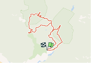

Longueur
10,8 km

Altitude max
196 m

Dénivelé positif
305 m
Km-Effort
14,8 km

Altitude min
27 m

Dénivelé négatif
303 m
Boucle
Oui
Date de création :
2020-01-30 19:06:19.09
Dernière modification :
2020-01-30 19:09:30.915
3h08
Difficulté : Difficile
--
Difficulté : Moyen

Application GPS de randonnée GRATUITE
 SityTrail
IGN / Instituts géographiques
SityTrail Plus
Le monde est à vous
À propos
Randonnée Marche de 10,8 km à découvrir à Provence-Alpes-Côte d'Azur, Var, Saint-Raphaël. Cette randonnée est proposée par jpb83.
Localisation
Pays :
France
Région :
Provence-Alpes-Côte d'Azur
Département/Province :
Var
Commune :
Saint-Raphaël
Localité :
Unknown
Départ:(Dec)
Départ:(UTM)
327577 ; 4813724 (32T) N.
Commentaires