Randonnée Moto Champfleury - Reims dormans  - Photo
 jcman51
jcman51

Utilisateur

© OpenStreetMap contributors
Longueur
Longueur
66 km
Altitude max
Altitude max
261 m
Dénivelé positif
Dénivelé positif
993 m
Km-Effort
Km-Effort  
79 km
Altitude min
Altitude min
59 m
Dénivelé négatif
Dénivelé négatif
1021 m
Boucle
Boucle
Non
Date de création :
2020-02-08 10:05:52.0
Dernière modification :
2020-02-08 16:49:18.364

(0 Avis)

Moto
Moto
6h39
Difficulté : Très difficile

Scannez ce code QR pour ouvrir la randonnée dans l'application SityTrail

Application GPS de randonnée GRATUITE

Logo SityTrail SityTrail

IGN / Instituts géographiques

Télécharger SityTrail sur l'App Store Télécharger SityTrail sur Google Play

Logo SityTrail SityTrail World

Le monde est à vous

Télécharger SityTrail sur l'App Store Télécharger SityTrail sur Google Play Télécharger SityTrail sur Huawei AppGallery

À propos

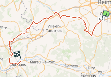
Randonnée Moto de 66 km à découvrir à Grand Est, Marne, Champfleury. Cette randonnée est proposée par jcman51.

Description

Reims dormais

Profil altimétrique

Localisation

Pays :
France
Région :
Grand Est
Département/Province :
Marne
Commune :
Champfleury
Localité :
Unknown
Départ:(Dec)
Départ:(UTM)
573749 ; 5450556 (31U) N.

Randonnées à proximité

Randonnée Marche Reims - Sablière du mont de Berru - Reims - Photo
Marche
tracegps

Marche

Difficile
(2)
Reims, Grand Est, Marne, France
18,1 km | 21 km-effort
4h 15min
Oui
Randonnée Course à pied Reims - Sablière du mont de Berru - Reims - Photo
Course à pied
tracegps

Course à pied

Difficile
Reims, Grand Est, Marne, France
18,1 km | 21 km-effort
1h 45min
Oui
Randonnée V.T.T. Villers-Allerand - La Montagne de Reims - Au SE de Villers-Allerand - Photo
V.T.T.
tracegps

V.T.T.

Difficile
Villers-Allerand, Grand Est, Marne, France
30 km | 38 km-effort
3h 0min
Oui
Randonnée Marche Écueil - Ecueil - Chamery 01 11 2012 - Photo
Marche
mousetik

Marche

Facile
Écueil, Grand Est, Marne, France
5,4 km | 7,1 km-effort
Inconnu
Oui
Randonnée Course à pied Reims - Reims - Tour Télécom du mont de Berru - Photo
Course à pied
tracegps

Course à pied

Difficile
Reims, Grand Est, Marne, France
20 km | 24 km-effort
2h 0min
Oui
Randonnée Course à pied Reims - De Reims à Cernay - Photo
Course à pied
tracegps

Course à pied

Difficile
Reims, Grand Est, Marne, France
14 km | 16 km-effort
1h 15min
Oui
Randonnée Marche Reims - La Via Francigena - Reims - Châlons en Champagne - Photo
Marche
tracegps

Marche

Moyen
Reims, Grand Est, Marne, France
61 km | 69 km-effort
12h 30min
Non
Randonnée Marche Reims - copain coubertin - Photo
Marche
Dominique Noyau

Marche

Facile
Reims, Grand Est, Marne, France
3,8 km | 4,3 km-effort
46min
Oui
Randonnée Cyclotourisme Reims - Reims - Condé sur marne 36 km - Photo
Cyclotourisme
GUIDE
jeanmarcMasson

Cyclotourisme

Difficile
Reims, Grand Est, Marne, France
36 km | 38 km-effort
2h 37min
Non


Fermer
Mes abonnements