


Gzwandschkopf

Bernardb44
Utilisateur

Longueur
15,1 km

Altitude max
1362 m

Dénivelé positif
336 m
Km-Effort
19,5 km

Altitude min
1114 m

Dénivelé négatif
335 m
Boucle
Oui
Date de création :
2020-02-16 09:10:18.413
Dernière modification :
2020-02-16 18:19:02.39
8h08
Difficulté : Moyen

Application GPS de randonnée GRATUITE
 SityTrail
IGN / Instituts géographiques
SityTrail Plus
Le monde est à vous
À propos
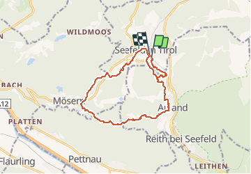
Randonnée Marche de 15,1 km à découvrir à Tyrol, Bezirk Innsbruck-Land, Gemeinde Seefeld in Tirol. Cette randonnée est proposée par Bernardb44.
Localisation
Pays :
Autriche
Région :
Tyrol
Département/Province :
Bezirk Innsbruck-Land
Commune :
Gemeinde Seefeld in Tirol
Localité :
Unknown
Départ:(Dec)
Départ:(UTM)
665432 ; 5243756 (32T) N.
Commentaires