Randonnée Marche Bera - GR 11 Stage 2: Bera - Elizondo - Photo

GR 11 Stage 2: Bera - Elizondo

 phelan
phelan

Utilisateur

© OpenStreetMap contributors
Longueur
Longueur
30 km
Altitude max
Altitude max
818 m
Dénivelé positif
Dénivelé positif
1334 m
Km-Effort
Km-Effort  
48 km
Altitude min
Altitude min
44 m
Dénivelé négatif
Dénivelé négatif
1180 m
Boucle
Boucle
Non
Date de création :
2020-03-03 13:46:31.231
Dernière modification :
2020-03-03 13:47:37.2

(0 Avis)

Marche
Marche
9h54
Difficulté : Très difficile

Scannez ce code QR pour ouvrir la randonnée dans l'application SityTrail

Application GPS de randonnée GRATUITE

Logo SityTrail SityTrail

IGN / Instituts géographiques

Télécharger SityTrail sur l'App Store Télécharger SityTrail sur Google Play

Logo SityTrail SityTrail World

Le monde est à vous

Télécharger SityTrail sur l'App Store Télécharger SityTrail sur Google Play Télécharger SityTrail sur Huawei AppGallery

À propos

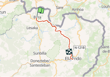
Randonnée Marche de 30 km à découvrir à Navarre, Inconnu, Bera. Cette randonnée est proposée par phelan.

Description

Distance/elevation: 29,6 km / ( 1.260 m), (-1.140 m)
Time 7h55min (walking time without stops).
Difficulty: A long stage with a lot of elevation gain and loss. The route is waymarked perfectly.
Water: One kilometre from Bera. On the way to Usateguieta you cross over a small river. The Inn at Lizarrieta.

Profil altimétrique

Localisation

Pays :
Espagne
Région :
Navarre
Département/Province :
Inconnu
Commune :
Bera
Localité :
Unknown
Départ:(UTM)
606928 ; 4792803 (30T) N.

Randonnées à proximité

Randonnée Marche Urrugne - Sentier des mulets  - Photo
Marche
RayFab

Marche

Moyen
Urrugne, Nouvelle-Aquitaine, Pyrénées-Atlantiques, France
9 km | 14 km-effort
2h 40min
Oui
Randonnée Marche Urrugne - ibardin- tour du lac  - Photo
Marche
RayFab

Marche

Moyen
(1)
Urrugne, Nouvelle-Aquitaine, Pyrénées-Atlantiques, France
10,5 km | 17,2 km-effort
4h 34min
Oui
Randonnée Marche Urrugne - Ibardin Ziburumendi, Yasola forêt de Bera  Gartzin - Photo
Marche
DECHAMPD

Marche

Moyen
Urrugne, Nouvelle-Aquitaine, Pyrénées-Atlantiques, France
12,1 km | 19,6 km-effort
4h 0min
Oui
Randonnée Marche Sare - La Rhune - Photo
Marche
donda

Marche

Moyen
Sare, Nouvelle-Aquitaine, Pyrénées-Atlantiques, France
6,7 km | 9,7 km-effort
2h 18min
Non
Randonnée Marche Biriatou - biriatou chemin de la foret - Photo
Marche
brindacier

Marche

Facile
Biriatou, Nouvelle-Aquitaine, Pyrénées-Atlantiques, France
4 km | 6,4 km-effort
1h 21min
Non
Randonnée Marche Lesaka - BERA-MÉGALITHES DE AMARGUNKO - Photo
Marche
DECHAMPD

Marche

Très facile
Lesaka, Navarre, Inconnu, Espagne
14,7 km | 22 km-effort
4h 44min
Non
Randonnée Raquettes à neige Bera - La Rhune depuis col Lizunaga avec sommet réal - Photo
Raquettes à neige
DECHAMPD

Raquettes à neige

Moyen
Bera, Navarre, Inconnu, Espagne
10,6 km | 19,8 km-effort
4h 17min
Oui
Randonnée Marche Bera - Massif de la  Rhune depuis col Lizunaga - Photo
Marche
DECHAMPD

Marche

Moyen
Bera, Navarre, Inconnu, Espagne
10,6 km | 19,7 km-effort
4h 11min
Oui
Randonnée Marche Urrugne - jara - Photo
Marche
jaja64

Marche

Moyen
Urrugne, Nouvelle-Aquitaine, Pyrénées-Atlantiques, France
48 km | 101 km-effort
5h 48min
Non


Fermer
Mes abonnements