Randonnée Trail Espeluche - Rochefort espeluche en boucle - Photo

Rochefort espeluche en boucle

 quercus26
quercus26

Utilisateur

© OpenStreetMap contributors
Longueur
Longueur
12,5 km
Altitude max
Altitude max
397 m
Dénivelé positif
Dénivelé positif
394 m
Km-Effort
Km-Effort  
17,7 km
Altitude min
Altitude min
161 m
Dénivelé négatif
Dénivelé négatif
394 m
Boucle
Boucle
Oui
Date de création :
2020-03-07 17:31:29.517
Dernière modification :
2020-03-07 17:34:07.864

(0 Avis)

Trail
Trail
1h30
Difficulté : Très facile

Scannez ce code QR pour ouvrir la randonnée dans l'application SityTrail

Application GPS de randonnée GRATUITE

Logo SityTrail SityTrail

IGN / Instituts géographiques

Télécharger SityTrail sur l'App Store Télécharger SityTrail sur Google Play

Logo SityTrail SityTrail World

Le monde est à vous

Télécharger SityTrail sur l'App Store Télécharger SityTrail sur Google Play Télécharger SityTrail sur Huawei AppGallery

À propos

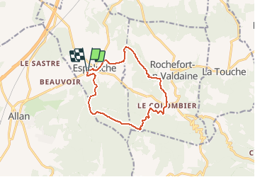
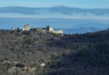
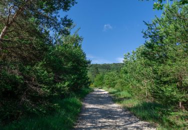
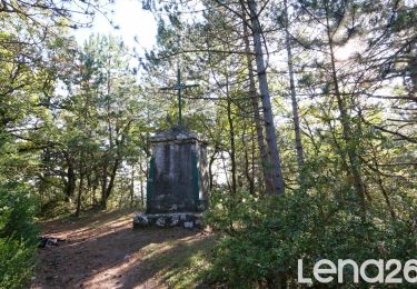
Randonnée Trail de 12,5 km à découvrir à Auvergne-Rhône-Alpes, Drôme, Espeluche. Cette randonnée est proposée par quercus26.

Profil altimétrique

Localisation

Pays :
France
Région :
Auvergne-Rhône-Alpes
Département/Province :
Drôme
Commune :
Espeluche
Localité :
Unknown
Départ:(UTM)
644655 ; 4930720 (31T) N.

Randonnées à proximité

Randonnée Marche Allan - allan transclavienne rac - Photo
Marche
micheleuvrard

Marche

Très facile
(1)
Allan, Auvergne-Rhône-Alpes, Drôme, France
19,1 km | 26 km-effort
5h 11min
Oui
Randonnée V.T.T. Puygiron - Puygiron VTT n°5 - Photo
V.T.T.
tracegps

V.T.T.

Très difficile
(1)
Puygiron, Auvergne-Rhône-Alpes, Drôme, France
47 km | 60 km-effort
3h 0min
Oui
Randonnée Marche La Touche - Citelles hameau et ruisseaux 10km - Photo
Marche
GUIDE
thonyc

Marche

Facile
(2)
La Touche, Auvergne-Rhône-Alpes, Drôme, France
9,6 km | 12,6 km-effort
3h 7min
Oui
Randonnée sport Allan - SityTrail - Les Villages Perchés. - Photo
sport
collot

sport

Très facile
(1)
Allan, Auvergne-Rhône-Alpes, Drôme, France
19,5 km | 27 km-effort
Inconnu
Oui
Randonnée Marche Montboucher-sur-Jabron - 20240428 Rando vieux  - Photo
Marche
Havani

Marche

Très facile
Montboucher-sur-Jabron, Auvergne-Rhône-Alpes, Drôme, France
6,1 km | 6,5 km-effort
5h 17min
Oui
Randonnée Marche Rochefort-en-Valdaine - Rochefort en Valdaine 7,5km - Photo
Marche
GUIDE
thonyc

Marche

Facile
Rochefort-en-Valdaine, Auvergne-Rhône-Alpes, Drôme, France
7,3 km | 10,3 km-effort
2h 30min
Oui
Randonnée Marche Allan - Allan Château de Rochefort en Valdaine - Photo
Marche
TOULAUDIN

Marche

Facile
Allan, Auvergne-Rhône-Alpes, Drôme, France
17,7 km | 26 km-effort
6h 6min
Oui
Randonnée Marche Espeluche - Bois-Jamot-Espeluche 11km - Photo
Marche
chancha

Marche

Moyen
(1)
Espeluche, Auvergne-Rhône-Alpes, Drôme, France
11,3 km | 15,4 km-effort
3h 28min
Oui
Randonnée Marche Allan - Allan La Croix de Siméon 11km - Photo
Marche
chancha

Marche

Moyen
Allan, Auvergne-Rhône-Alpes, Drôme, France
10,7 km | 15,2 km-effort
3h 27min
Oui


Fermer
Mes abonnements