


boucle Fouyr

Lychee
Utilisateur
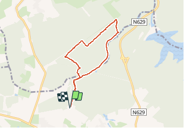

Longueur
6,2 km

Altitude max
378 m

Dénivelé positif
145 m
Km-Effort
8,2 km

Altitude min
283 m

Dénivelé négatif
147 m
Boucle
Oui
Date de création :
2020-03-08 12:45:15.362
Dernière modification :
2020-03-08 14:41:38.149
1h55
Difficulté : Très facile

Application GPS de randonnée GRATUITE
 SityTrail
IGN / Instituts géographiques
SityTrail Plus
Le monde est à vous
À propos
Randonnée Marche de 6,2 km à découvrir à Wallonie, Liège, Jalhay. Cette randonnée est proposée par Lychee.
Localisation
Pays :
Belgique
Région :
Wallonie
Département/Province :
Liège
Commune :
Jalhay
Localité :
Jalhay
Départ:(Dec)
Départ:(UTM)
708619 ; 5606500 (31U) N.
Commentaires