Randonnée Marche Aurignac - 31_Aurignac - Photo
 jab31
jab31

Utilisateur

© OpenStreetMap contributors
Longueur
Longueur
15,5 km
Altitude max
Altitude max
486 m
Dénivelé positif
Dénivelé positif
442 m
Km-Effort
Km-Effort  
21 km
Altitude min
Altitude min
276 m
Dénivelé négatif
Dénivelé négatif
447 m
Boucle
Boucle
Oui
Date de création :
2017-11-05 00:00:00.0
Dernière modification :
2017-11-05 00:00:00.0

(1 Avis)

Marche
Marche
3h16
Difficulté : Difficile

Scannez ce code QR pour ouvrir la randonnée dans l'application SityTrail

Application GPS de randonnée GRATUITE

Logo SityTrail SityTrail

IGN / Instituts géographiques

Télécharger SityTrail sur l'App Store Télécharger SityTrail sur Google Play

Logo SityTrail SityTrail World

Le monde est à vous

Télécharger SityTrail sur l'App Store Télécharger SityTrail sur Google Play Télécharger SityTrail sur Huawei AppGallery

À propos

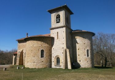
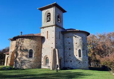
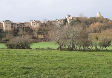
Randonnée Marche de 15,5 km à découvrir à Occitanie, Haute-Garonne, Aurignac. Cette randonnée est proposée par jab31.

Description

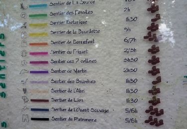
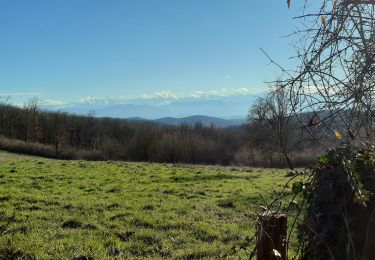
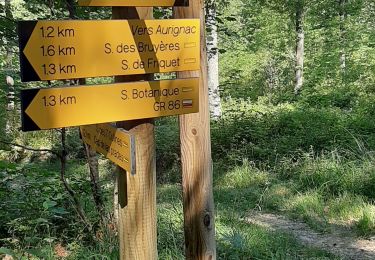
bois d'Aurignac et Louge; bois et vallée

Profil altimétrique

Localisation

Pays :
France
Région :
Occitanie
Département/Province :
Haute-Garonne
Commune :
Aurignac
Localité :
Unknown
Départ:(Dec)
Départ:(UTM)
328081 ; 4787037 (31T) N.

Commentaires

Veuillez vous connecter pour laisser un commentaire ou une note


Randonnées à proximité

Randonnée Marche Aurignac - Chapelle St-Bernard - Aurignac - Photo
Marche
tracegps

Marche

Moyen
Aurignac, Occitanie, Haute-Garonne, France
10,5 km | 15 km-effort
3h 0min
Oui
Randonnée Marche Aurignac - Chemin du Patrimoine - Aurignac - Photo
Marche
tracegps

Marche

Moyen
(1)
Aurignac, Occitanie, Haute-Garonne, France
13,2 km | 18,4 km-effort
4h 0min
Oui
Randonnée Marche Aurignac - la chapelle Notre-Dame de St Bernard en boucle depuis Aurignac - Photo
Marche
GUIDE
lhomme.ph

Marche

Moyen
Aurignac, Occitanie, Haute-Garonne, France
13,7 km | 19,4 km-effort
4h 41min
Oui
Randonnée Marche Aurignac - Sentier des 7 collines - Balades et randonnées au Pays de l'Aurignacien - Photo
Marche
philou6351

Marche

Moyen
Aurignac, Occitanie, Haute-Garonne, France
15 km | 21 km-effort
4h 25min
Oui
Randonnée Marche Aurignac - Aurignac Sentier Botanique  - Photo
Marche
olivicol

Marche

Très facile
Aurignac, Occitanie, Haute-Garonne, France
4,5 km | 6,3 km-effort
1h 4min
Oui
Randonnée Marche Aurignac - boucle depuis Aurignac - Photo
Marche
GUIDE
lhomme.ph

Marche

Moyen
Aurignac, Occitanie, Haute-Garonne, France
9,8 km | 14 km-effort
3h 21min
Oui
Randonnée Marche Alan - Alan - Photo
Marche
pidjam

Marche

Difficile
Alan, Occitanie, Haute-Garonne, France
10,8 km | 14,9 km-effort
3h 22min
Oui
Randonnée Marche Boussan - Aurignac S. Botanique  - Photo
Marche
olivicol

Marche

Très facile
Boussan, Occitanie, Haute-Garonne, France
1,9 km | 2,7 km-effort
32min
Non
Randonnée Marche Aurignac - Ligne Verte des Terres d'Aurignac - Photo
Marche
martoche

Marche

Très facile
Aurignac, Occitanie, Haute-Garonne, France
82 km | 102 km-effort
Inconnu
Oui


Fermer
Mes abonnements