Randonnée V.T.T. Port-sur-Saône - VTT Montigny les Vesoul - Photo
 vathi54
vathi54

Utilisateur

© OpenStreetMap contributors
Longueur
Longueur
31 km
Altitude max
Altitude max
316 m
Dénivelé positif
Dénivelé positif
514 m
Km-Effort
Km-Effort  
38 km
Altitude min
Altitude min
204 m
Dénivelé négatif
Dénivelé négatif
514 m
Boucle
Boucle
Oui
Date de création :
2020-05-10 09:44:16.374
Dernière modification :
2020-05-10 13:17:13.855

(0 Avis)

V.T.T.
V.T.T.
3h32
Difficulté : Facile

Scannez ce code QR pour ouvrir la randonnée dans l'application SityTrail

Application GPS de randonnée GRATUITE

Logo SityTrail SityTrail

IGN / Instituts géographiques

Télécharger SityTrail sur l'App Store Télécharger SityTrail sur Google Play

Logo SityTrail SityTrail World

Le monde est à vous

Télécharger SityTrail sur l'App Store Télécharger SityTrail sur Google Play Télécharger SityTrail sur Huawei AppGallery

À propos

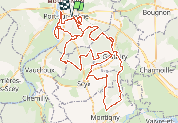
Randonnée V.T.T. de 31 km à découvrir à Bourgogne-Franche-Comté, Haute-Saône, Port-sur-Saône. Cette randonnée est proposée par vathi54.

Description

Rando variée avec alternance de singles, chemins forestiers basée sur le circuit VTT #16 avec extension vers Montigny.

Profil altimétrique

Photos

Localisation

Pays :
France
Région :
Bourgogne-Franche-Comté
Département/Province :
Haute-Saône
Commune :
Port-sur-Saône
Localité :
Unknown
Départ:(UTM)
278607 ; 5285770 (32T) N.

Randonnées à proximité

Randonnée V.T.T. Villers-sur-Port - Sentier de la tuilerie - Villers-sur-Port - Photo
V.T.T.
tracegps

V.T.T.

Moyen
Villers-sur-Port, Bourgogne-Franche-Comté, Haute-Saône, France
13,9 km | 17,2 km-effort
1h 15min
Oui
Randonnée V.T.T. Port-sur-Saône - VTT port sur Saône 03/05/20 - Photo
V.T.T.
vathi54

V.T.T.

Facile
Port-sur-Saône, Bourgogne-Franche-Comté, Haute-Saône, France
19,7 km | 25 km-effort
2h 39min
Oui
Randonnée Marche Ferrières-lès-Scey - Saône - Photo
Marche
michelelfn

Marche

Très facile
Ferrières-lès-Scey, Bourgogne-Franche-Comté, Haute-Saône, France
5,4 km | 5,8 km-effort
1h 29min
Oui
Randonnée Marche Scey-sur-Saône-et-Saint-Albin - Parcours santé chanois  - Photo
Marche
nicolasdresse

Marche

Facile
Scey-sur-Saône-et-Saint-Albin, Bourgogne-Franche-Comté, Haute-Saône, France
4,8 km | 5,9 km-effort
1h 16min
Oui
Randonnée Marche Bougnon -  Bougnon nov21 - Photo
Marche
Jean M

Marche

Facile
Bougnon, Bourgogne-Franche-Comté, Haute-Saône, France
12,2 km | 15,4 km-effort
3h 6min
Oui
Randonnée V.T.C. Port-sur-Saône - port-la-saône/Baulay  - Photo
V.T.C.
bernadette revoux

V.T.C.

Facile
Port-sur-Saône, Bourgogne-Franche-Comté, Haute-Saône, France
16,2 km | 20 km-effort
4h 8min
Non
Randonnée Marche Scye - le bois de la patiotte  - Photo
Marche
nicolasdresse

Marche

Très facile
Scye, Bourgogne-Franche-Comté, Haute-Saône, France
4,8 km | 5,9 km-effort
1h 22min
Oui
Randonnée Marche Bougnon - Bougnon - Gare de Vesoul - Photo
Marche
ballet

Marche

Moyen
Bougnon, Bourgogne-Franche-Comté, Haute-Saône, France
10,3 km | 11,1 km-effort
2h 26min
Non
Randonnée Marche Bougnon - Bougnon - Garre de Vesoul - Photo
Marche
ballet

Marche

Très facile
Bougnon, Bourgogne-Franche-Comté, Haute-Saône, France
10,2 km | 11,1 km-effort
2h 0min
Non


Fermer
Mes abonnements