


Vlessart

papa-sanglier
Utilisateur
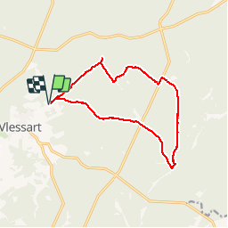

Longueur
12,5 km

Altitude max
502 m

Dénivelé positif
210 m
Km-Effort
15,3 km

Altitude min
421 m

Dénivelé négatif
212 m
Boucle
Oui
Date de création :
2014-12-10 00:00:00.0
Dernière modification :
2014-12-10 00:00:00.0
2h28
Difficulté : Facile

Application GPS de randonnée GRATUITE
 SityTrail
IGN / Instituts géographiques
SityTrail Plus
Le monde est à vous
À propos
Randonnée Marche de 12,5 km à découvrir à Wallonie, Luxembourg, Martelange. Cette randonnée est proposée par papa-sanglier.
Description
Oxygène Nature
Localisation
Pays :
Belgique
Région :
Wallonie
Département/Province :
Luxembourg
Commune :
Martelange
Localité :
Martelange
Départ:(Dec)
Départ:(UTM)
691341 ; 5519819 (31U) N.
Commentaires
Belle balade dans les bois.
Mooie, duidelijke wandeling. Goed begaanbare paden. Veel natuurschoon en hoogtepunten. Een aanrader als je het bos van Anlier wilt ontdekken. Gelopen met 2 honden op leeftijd en dat ging goed! Belle randonnee!