Randonnée Marche Montigny-sur-Avre - 2020_05_Montigny sur Avre_Arbres remarquables - Photo

2020_05_Montigny sur Avre_Arbres remarquables

 jeanlucien
jeanlucien

Utilisateur

© OpenStreetMap contributors
Longueur
Longueur
11,3 km
Altitude max
Altitude max
180 m
Dénivelé positif
Dénivelé positif
113 m
Km-Effort
Km-Effort  
12,8 km
Altitude min
Altitude min
143 m
Dénivelé négatif
Dénivelé négatif
113 m
Boucle
Boucle
Oui
Date de création :
2020-05-28 14:20:37.24
Dernière modification :
2020-05-28 14:22:22.697

(0 Avis)

Marche
Marche
2h30
Difficulté : Moyen

Scannez ce code QR pour ouvrir la randonnée dans l'application SityTrail

Application GPS de randonnée GRATUITE

Logo SityTrail SityTrail

IGN / Instituts géographiques

Télécharger SityTrail sur l'App Store Télécharger SityTrail sur Google Play

Logo SityTrail SityTrail World

Le monde est à vous

Télécharger SityTrail sur l'App Store Télécharger SityTrail sur Google Play Télécharger SityTrail sur Huawei AppGallery

À propos

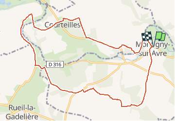
Randonnée Marche de 11,3 km à découvrir à Centre-Val de Loire, Eure-et-Loir, Montigny-sur-Avre. Cette randonnée est proposée par jeanlucien.
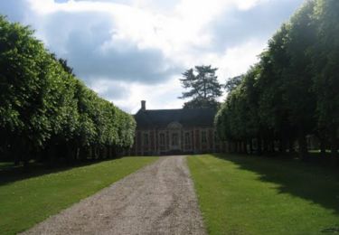
Description

Belle demeures
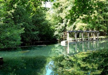
Sur fin de parcours, arbres remarquables au bord de l'Avre.

Profil altimétrique

Localisation

Pays :
France
Région :
Centre-Val de Loire
Département/Province :
Eure-et-Loir
Commune :
Montigny-sur-Avre
Localité :
Unknown
Départ:(UTM)
354531 ; 5399302 (31U) N.

Randonnées à proximité

Randonnée Marche Rueil-la-Gadelière - Sur les Pas de Vlaminck -  Rueil-la-Gadelière - Photo
Marche
tracegps

Marche

Moyen
Rueil-la-Gadelière, Centre-Val de Loire, Eure-et-Loir, France
8,3 km | 9,2 km-effort
2h 4min
Oui
Randonnée V.T.T. Tillières-sur-Avre - De Tillières sur Avre à Ormes - Photo
V.T.T.
tracegps

V.T.T.

Moyen
Tillières-sur-Avre, Normandie, Eure, France
61 km | 68 km-effort
3h 30min
Non
Randonnée Marche Courteilles - Circuit des Dames - Courteilles - Photo
Marche
tracegps

Marche

Facile
(1)
Courteilles, Normandie, Eure, France
2,7 km | 3 km-effort
40min
Oui
Randonnée A pied Breux-sur-Avre - Le Rousset d'Acon 19.50 - Photo
A pied
togolo28

A pied

Moyen
Breux-sur-Avre, Normandie, Eure, France
19,5 km | 0 m-effort
Inconnu
Oui
Randonnée V.T.T. Tillières-sur-Avre - tillieres sur avre - Photo
V.T.T.
nolouca

V.T.T.

Facile
Tillières-sur-Avre, Normandie, Eure, France
30 km | 35 km-effort
2h 11min
Oui
Randonnée V.T.T. Tillières-sur-Avre - autour de tillieres sur avre  - Photo
V.T.T.
nolouca

V.T.T.

Moyen
Tillières-sur-Avre, Normandie, Eure, France
26 km | 29 km-effort
1h 40min
Oui
Randonnée V.T.T. Tillières-sur-Avre - tillieres sur avre - Photo
V.T.T.
nolouca

V.T.T.

Moyen
Tillières-sur-Avre, Normandie, Eure, France
25 km | 28 km-effort
1h 35min
Oui
Randonnée V.T.T. Tillières-sur-Avre - autour de tillieres sur avre  - Photo
V.T.T.
nolouca

V.T.T.

Moyen
Tillières-sur-Avre, Normandie, Eure, France
42 km | 49 km-effort
5h 49min
Oui
Randonnée Vélo Breux-sur-Avre - Château de Chambrais - Photo
Vélo
bomer

Vélo

Très facile
Breux-sur-Avre, Normandie, Eure, France
30 km | 33 km-effort
2h 12min
Oui


Fermer
Mes abonnements