Randonnée Marche Saint-Sever - 3 vallées St sever - Photo
 DuMarsan
DuMarsan

Utilisateur

© OpenStreetMap contributors
Longueur
Longueur
13,9 km
Altitude max
Altitude max
118 m
Dénivelé positif
Dénivelé positif
212 m
Km-Effort
Km-Effort  
16,8 km
Altitude min
Altitude min
36 m
Dénivelé négatif
Dénivelé négatif
211 m
Boucle
Boucle
Oui
Date de création :
2014-12-10 00:00:00.0
Dernière modification :
2014-12-10 00:00:00.0

(1 Avis)

Marche
Marche
2h39
Difficulté : Facile

Scannez ce code QR pour ouvrir la randonnée dans l'application SityTrail

Application GPS de randonnée GRATUITE

Logo SityTrail SityTrail

IGN / Instituts géographiques

Télécharger SityTrail sur l'App Store Télécharger SityTrail sur Google Play

Logo SityTrail SityTrail World

Le monde est à vous

Télécharger SityTrail sur l'App Store Télécharger SityTrail sur Google Play Télécharger SityTrail sur Huawei AppGallery

À propos

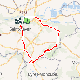
Randonnée Marche de 13,9 km à découvrir à Nouvelle-Aquitaine, Landes, Saint-Sever. Cette randonnée est proposée par DuMarsan.

Description

Les 3 vallées sont peu perceptibles

Profil altimétrique

Localisation

Pays :
France
Région :
Nouvelle-Aquitaine
Département/Province :
Landes
Commune :
Saint-Sever
Localité :
Unknown
Départ:(Dec)
Départ:(UTM)
695526 ; 4847873 (30T) N.

Commentaires

Veuillez vous connecter pour laisser un commentaire ou une note


Randonnées à proximité

Randonnée Marche Audignon - debut st sever hagetmau - Photo
Marche
hourmilougue

Marche

Très facile
Audignon, Nouvelle-Aquitaine, Landes, France
7,6 km | 9,3 km-effort
54min
Non
Randonnée Marche Banos - Banos-Montaut - Photo
Marche
ollivier.albert

Marche

Moyen
Banos, Nouvelle-Aquitaine, Landes, France
10,8 km | 13,6 km-effort
2h 59min
Oui
Randonnée Marche Saint-Sever - saint sever Guillaume - Photo
Marche
Brigitte Subrenat

Marche

Moyen
Saint-Sever, Nouvelle-Aquitaine, Landes, France
9,9 km | 11,6 km-effort
2h 28min
Oui
Randonnée V.T.T. Saint-Sever - 11 St Sever-ST Jean Pied de Port-St Jacques de Compostelle - Photo
V.T.T.
nicolas54230

V.T.T.

Très difficile
Saint-Sever, Nouvelle-Aquitaine, Landes, France
116 km | 147 km-effort
9h 14min
Non
Randonnée V.T.T. Saint-Sever - Saint Sever - Hinx - 31 Km - Photo
V.T.T.
potofe

V.T.T.

Facile
Saint-Sever, Nouvelle-Aquitaine, Landes, France
31 km | 35 km-effort
1h 30min
Non
Randonnée Marche Saint-Sever - Chemin de Compostelle -vieille route Hagetmau  - Photo
Marche
Thetis De Villeroy

Marche

Moyen
Saint-Sever, Nouvelle-Aquitaine, Landes, France
5,9 km | 7 km-effort
1h 27min
Oui
Randonnée Marche Saint-Sever - Chemin Poureille Crampot - Photo
Marche
Thetis De Villeroy

Marche

Moyen
Saint-Sever, Nouvelle-Aquitaine, Landes, France
7,3 km | 8,3 km-effort
1h 38min
Oui
Randonnée Marche Saint-Sever - Fg - Photo
Marche
Thetis De Villeroy

Marche

Moyen
Saint-Sever, Nouvelle-Aquitaine, Landes, France
11,1 km | 12,7 km-effort
2h 18min
Non
Randonnée Marche Saint-Sever - Fleuris - Photo
Marche
Thetis De Villeroy

Marche

Moyen
Saint-Sever, Nouvelle-Aquitaine, Landes, France
8,5 km | 9,5 km-effort
2h 1min
Non


Fermer
Mes abonnements