


2020-07-05 langen-soultzthal-gunsthal-langen BIS

maureengeorges
Utilisateur
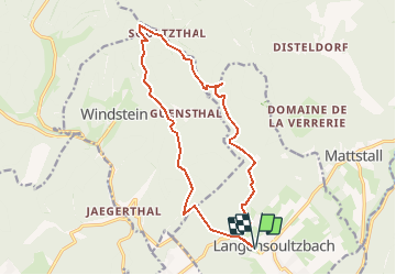

Longueur
15 km

Altitude max
470 m

Dénivelé positif
397 m
Km-Effort
20 km

Altitude min
213 m

Dénivelé négatif
397 m
Boucle
Oui
Date de création :
2020-07-02 11:50:45.461
Dernière modification :
2020-07-02 11:56:37.071
2h29
Difficulté : Facile

Application GPS de randonnée GRATUITE
 SityTrail
IGN / Instituts géographiques
SityTrail Plus
Le monde est à vous
À propos
Randonnée Randonnée équestre de 15 km à découvrir à Grand Est, Bas-Rhin, Langensoultzbach. Cette randonnée est proposée par maureengeorges.
Localisation
Pays :
France
Région :
Grand Est
Département/Province :
Bas-Rhin
Commune :
Langensoultzbach
Localité :
Unknown
Départ:(Dec)
Départ:(UTM)
406918 ; 5424627 (32U) N.
Commentaires