


SURCENEUX LIEZEY

surceneux
Utilisateur
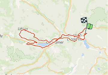

Longueur
38 km

Altitude max
910 m

Dénivelé positif
837 m
Km-Effort
49 km

Altitude min
625 m

Dénivelé négatif
834 m
Boucle
Non
Date de création :
2020-07-09 06:22:38.738
Dernière modification :
2020-07-09 10:13:45.692
2h30
Difficulté : Moyen

Application GPS de randonnée GRATUITE
 SityTrail
IGN / Instituts géographiques
SityTrail Plus
Le monde est à vous
À propos
Randonnée V.T.C. de 38 km à découvrir à Grand Est, Vosges, Xonrupt-Longemer. Cette randonnée est proposée par surceneux.
Description
SURCENEUX LIEZEY VIA LAC LONGEMER/GERARDMER RETOUR PAR ROUGIMONT
Localisation
Pays :
France
Région :
Grand Est
Département/Province :
Vosges
Commune :
Xonrupt-Longemer
Localité :
Unknown
Départ:(Dec)
Départ:(UTM)
347298 ; 5328027 (32U) N.
Commentaires