![](/images/other/stat-length.png)
![Randonnée A pied Lavars - Villarnet passerelle du Drac - Photo](https://media.geolcdn.com/t/1900/400/ext.pjpeg?maxdim=2&url=https%3A%2F%2Fstatic1.geolcdn.com%2Fsiteimages%2Fupload%2Ffiles%2F1545311037marcheuse_200dpi.jpg)
Villarnet passerelle du Drac
rigol05
Utilisateur
![Longueur](/images/other/stat-length.png)
Longueur
5,5 km
![Altitude max](https://static1.geolcdn.com/siteimages/upload/files/1508320355ic_sort_altitude_max_24dp.png)
Altitude max
687 m
![Dénivelé positif](https://static1.geolcdn.com/siteimages/upload/files/1508320355ic_sort_den_pos_24dp.png)
Dénivelé positif
291 m
![Km-Effort](/images/other/stat-length.png)
Km-Effort
9,4 km
![Altitude min](https://static1.geolcdn.com/siteimages/upload/files/1508320355ic_sort_altitude_min_24dp.png)
Altitude min
470 m
![Dénivelé négatif](https://static1.geolcdn.com/siteimages/upload/files/1508320355ic_sort_den_neg_24dp.png)
Dénivelé négatif
288 m
![Boucle](https://static1.geolcdn.com/siteimages/upload/files/16400158638029165_repeat_loop_refresh_sync_direction_icon.png)
Boucle
Oui
Date de création :
2020-07-26 07:23:59.01
Dernière modification :
2020-07-26 07:34:24.712
![A pied](https://static1.geolcdn.com/sitytour/trail-icons/100.png)
--
Difficulté : Moyen
![Scannez ce code QR pour ouvrir la randonnée dans l'application SityTrail](https://capi.geolives.com/qq0zvz2zws4bq2lad0pu/sitytour/trails/2490230/qr.png?size=200)
Application GPS de randonnée GRATUITE
À propos
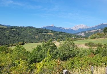
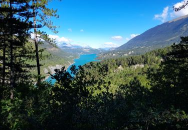
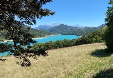
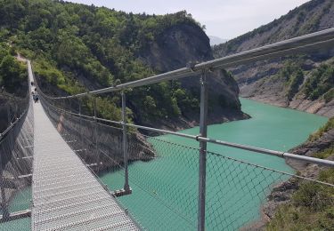
Randonnée A pied de 5,5 km à découvrir à Auvergne-Rhône-Alpes, Isère, Lavars. Cette randonnée est proposée par rigol05.
Description
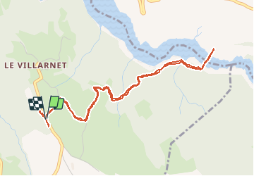
Du parking du Villarnet, itinéraire en A/R pour accéder à la passerelle himalayenne du Drac. Du même endroit, possibilité de rejoindre la passerelle de l'Ebron en A/R.
Sortie du 22/07/2020
Localisation
Pays :
France
Région :
Auvergne-Rhône-Alpes
Département/Province :
Isère
Commune :
Lavars
Localité :
Unknown
Départ:(Dec)
Départ:(UTM)
712436 ; 4971320 (31T) N.
Commentaires
Randonnées à proximité
![Randonnée Marche Mayres-Savel - Passerelles Hymalayene Mayres + 250 - Photo](https://media.geolcdn.com/t/375/260/ext.jpg?maxdim=2&url=https%3A%2F%2Fmedia.geolcdn.com%2Ff%2Fe79ec6b2-c62a-43e0-95ca-91baa034bf5d.jpg)
![Marche Marche](https://static1.geolcdn.com/sitytour/trail-icons/101.png)
Passerelles Hymalayene Mayres + 250
Marche
Moyen
Mayres-Savel,
Auvergne-Rhône-Alpes,
Isère,
France
![](/images/other/stat-length.png)
4,9 km | 8,2 km-effort
1h 59min
![](https://static1.geolcdn.com/siteimages/upload/files/16400158638029165_repeat_loop_refresh_sync_direction_icon.png)
Oui
![Randonnée Marche Treffort - ISERE: MONTEYNARD PASSERELLES HIMALAYENNES - Photo](https://media.geolcdn.com/t/375/260/ext.jpg?maxdim=2&url=https%3A%2F%2Fmedia.geolcdn.com%2Ff%2F76721c9b-6b33-4db9-86bf-ba7e9a8d140f.jpg)
![Marche Marche](https://static1.geolcdn.com/sitytour/trail-icons/101.png)
ISERE: MONTEYNARD PASSERELLES HIMALAYENNES
Marche
Moyen
Treffort,
Auvergne-Rhône-Alpes,
Isère,
France
![](/images/other/stat-length.png)
16,1 km | 22 km-effort
3h 52min
![](https://static1.geolcdn.com/siteimages/upload/files/16400158638029165_repeat_loop_refresh_sync_direction_icon.png)
Oui
![Randonnée Marche Mayres-Savel - Randonnée des passerelles - Photo](https://media.geolcdn.com/t/375/260/ext.jpg?maxdim=2&url=https%3A%2F%2Fmedia.geolcdn.com%2Ff%2Ff81885ad-9d99-466e-990d-175fbd3a925e.jpg)
![Marche Marche](https://static1.geolcdn.com/sitytour/trail-icons/101.png)
Randonnée des passerelles
Marche
Facile
Mayres-Savel,
Auvergne-Rhône-Alpes,
Isère,
France
![](/images/other/stat-length.png)
11,9 km | 17,9 km-effort
4h 51min
![](https://static1.geolcdn.com/siteimages/upload/files/16400158638029165_repeat_loop_refresh_sync_direction_icon.png)
Non
![Randonnée Marche Treffort - Valgo2 - J3. : les passerelles de Monteynard - Photo](https://media.geolcdn.com/t/375/260/ext.jpg?maxdim=2&url=https%3A%2F%2Fmedia.geolcdn.com%2Ff%2F80ded9ce-faa3-4fe9-b5ad-3607bd08278e.jpg)
![Marche Marche](https://static1.geolcdn.com/sitytour/trail-icons/101.png)
Valgo2 - J3. : les passerelles de Monteynard
Marche
Facile
Treffort,
Auvergne-Rhône-Alpes,
Isère,
France
![](/images/other/stat-length.png)
12,4 km | 18,6 km-effort
2h 42min
![](https://static1.geolcdn.com/siteimages/upload/files/16400158638029165_repeat_loop_refresh_sync_direction_icon.png)
Non
![Randonnée Marche Treffort - Les deux passerelles Drac et Ebron - Photo](https://media.geolcdn.com/t/375/260/ext.jpg?maxdim=2&url=https%3A%2F%2Fmedia.geolcdn.com%2Ff%2F3778f66d-36c2-41c5-9e06-64b09fbd2374.jpg)
![Marche Marche](https://static1.geolcdn.com/sitytour/trail-icons/101.png)
Les deux passerelles Drac et Ebron
Marche
Moyen
Treffort,
Auvergne-Rhône-Alpes,
Isère,
France
![](/images/other/stat-length.png)
15,8 km | 25 km-effort
3h 23min
![](https://static1.geolcdn.com/siteimages/upload/files/16400158638029165_repeat_loop_refresh_sync_direction_icon.png)
Oui
![Randonnée Marche Mayres-Savel - Passerelles Du Drac Et de L'Ebron - Photo](https://media.geolcdn.com/t/375/260/ext.jpg?maxdim=2&url=https%3A%2F%2Fmedia.geolcdn.com%2Ff%2Ff4846bf3-414e-4c51-a6cb-c2da9b823649.jpg)
![Marche Marche](https://static1.geolcdn.com/sitytour/trail-icons/101.png)
Passerelles Du Drac Et de L'Ebron
Marche
Facile
Mayres-Savel,
Auvergne-Rhône-Alpes,
Isère,
France
![](/images/other/stat-length.png)
12,2 km | 18,4 km-effort
3h 13min
![](https://static1.geolcdn.com/siteimages/upload/files/16400158638029165_repeat_loop_refresh_sync_direction_icon.png)
Non
![Randonnée Marche Lavars - Serre de la Fayolle - Photo](https://media.geolcdn.com/t/375/260/ext.jpg?maxdim=2&url=https%3A%2F%2Fmedia.geolcdn.com%2Ff%2F95bdaed1-9210-48db-8488-a02aafbf5b89.jpg)
![Marche Marche](https://static1.geolcdn.com/sitytour/trail-icons/101.png)
Serre de la Fayolle
Marche
Moyen
Lavars,
Auvergne-Rhône-Alpes,
Isère,
France
![](/images/other/stat-length.png)
13,3 km | 19,9 km-effort
5h 53min
![](https://static1.geolcdn.com/siteimages/upload/files/16400158638029165_repeat_loop_refresh_sync_direction_icon.png)
Oui
![Randonnée Marche Treffort - Passerelle de l'Ebron. pointe de la Condamine, pas de Berlioz - Photo](https://media.geolcdn.com/t/375/260/ext.jpg?maxdim=2&url=https%3A%2F%2Fmedia.geolcdn.com%2Ff%2Fd02366ad-0139-4ee6-b13c-ef6ca7fda045.jpg)
![Marche Marche](https://static1.geolcdn.com/sitytour/trail-icons/101.png)
Passerelle de l'Ebron. pointe de la Condamine, pas de Berlioz
Marche
Facile
Treffort,
Auvergne-Rhône-Alpes,
Isère,
France
![](/images/other/stat-length.png)
13,1 km | 20 km-effort
5h 18min
![](https://static1.geolcdn.com/siteimages/upload/files/16400158638029165_repeat_loop_refresh_sync_direction_icon.png)
Oui
![Randonnée Marche Treffort - Les Passerelles du Monteynard - Photo](https://media.geolcdn.com/t/375/260/ext.jpg?maxdim=2&url=https%3A%2F%2Fmedia.geolcdn.com%2Ff%2F60997083-3256-4c0a-894f-b64ee2eb3d05.jpg)
![Marche Marche](https://static1.geolcdn.com/sitytour/trail-icons/101.png)
Les Passerelles du Monteynard
Marche
Moyen
Treffort,
Auvergne-Rhône-Alpes,
Isère,
France
![](/images/other/stat-length.png)
16,6 km | 23 km-effort
5h 0min
![](https://static1.geolcdn.com/siteimages/upload/files/16400158638029165_repeat_loop_refresh_sync_direction_icon.png)
Oui