


Lailly en Val 2014

Sugg
Utilisateur
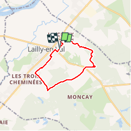

Longueur
9,7 km

Altitude max
108 m

Dénivelé positif
50 m
Km-Effort
10,3 km

Altitude min
88 m

Dénivelé négatif
49 m
Boucle
Oui
Date de création :
2019-03-22 17:00:17.323
Dernière modification :
2019-04-23 17:33:45.997
2h19
Difficulté : Très facile

Application GPS de randonnée GRATUITE
 SityTrail
IGN / Instituts géographiques
SityTrail Plus
Le monde est à vous
À propos
Randonnée Marche de 9,7 km à découvrir à Centre-Val de Loire, Loiret, Lailly-en-Val. Cette randonnée est proposée par Sugg.
Description
Promenade au sud de Lailly le 17-02-2014
Localisation
Pays :
France
Région :
Centre-Val de Loire
Département/Province :
Loiret
Commune :
Lailly-en-Val
Localité :
Unknown
Départ:(Dec)
Départ:(UTM)
402518 ; 5291661 (31T) N.
Commentaires