


Beaufortain J2

Airelle
Utilisateur
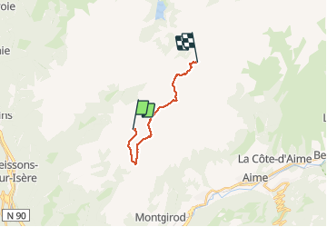

Longueur
12,9 km

Altitude max
2443 m

Dénivelé positif
665 m
Km-Effort
22 km

Altitude min
2002 m

Dénivelé négatif
688 m
Boucle
Non
Date de création :
2020-08-08 07:10:56.0
Dernière modification :
2020-08-14 15:01:33.081
6h48
Difficulté : Inconnu

Application GPS de randonnée GRATUITE
 SityTrail
IGN / Instituts géographiques
SityTrail Plus
Le monde est à vous
À propos
Randonnée Marche de 12,9 km à découvrir à Auvergne-Rhône-Alpes, Savoie, La Léchère. Cette randonnée est proposée par Airelle.
Localisation
Pays :
France
Région :
Auvergne-Rhône-Alpes
Département/Province :
Savoie
Commune :
La Léchère
Localité :
Naves
Départ:(Dec)
Départ:(UTM)
309611 ; 5050599 (32T) N.
Commentaires