


ORBEY - Lac Noir - Lac Blanc - Col de Calvaire

maureengeorges
Utilisateur
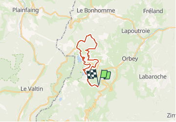

Longueur
21 km

Altitude max
1147 m

Dénivelé positif
693 m
Km-Effort
30 km

Altitude min
859 m

Dénivelé négatif
694 m
Boucle
Oui
Date de création :
2020-08-16 15:32:03.783
Dernière modification :
2020-08-16 15:33:02.589
3h38
Difficulté : Moyen

Application GPS de randonnée GRATUITE
 SityTrail
IGN / Instituts géographiques
SityTrail Plus
Le monde est à vous
À propos
Randonnée Randonnée équestre de 21 km à découvrir à Grand Est, Haut-Rhin, Orbey. Cette randonnée est proposée par maureengeorges.
Localisation
Pays :
France
Région :
Grand Est
Département/Province :
Haut-Rhin
Commune :
Orbey
Localité :
Unknown
Départ:(Dec)
Départ:(UTM)
359933 ; 5329300 (32U) N.
Commentaires