Randonnée V.T.T. Sommedieue - BEHOLLE 70KM 2020 - Photo

BEHOLLE 70KM 2020

 Tollard
Tollard

Utilisateur

© OpenStreetMap contributors
Longueur
Longueur
69 km
Altitude max
Altitude max
389 m
Dénivelé positif
Dénivelé positif
1648 m
Km-Effort
Km-Effort  
91 km
Altitude min
Altitude min
215 m
Dénivelé négatif
Dénivelé négatif
1649 m
Boucle
Boucle
Oui
Date de création :
2020-09-06 06:15:32.378
Dernière modification :
2020-09-10 14:05:22.66

(0 Avis)

V.T.T.
V.T.T.
5h58
Difficulté : Moyen

Scannez ce code QR pour ouvrir la randonnée dans l'application SityTrail

Application GPS de randonnée GRATUITE

Logo SityTrail SityTrail

IGN / Instituts géographiques

Télécharger SityTrail sur l'App Store Télécharger SityTrail sur Google Play

Logo SityTrail SityTrail World

Le monde est à vous

Télécharger SityTrail sur l'App Store Télécharger SityTrail sur Google Play Télécharger SityTrail sur Huawei AppGallery

À propos

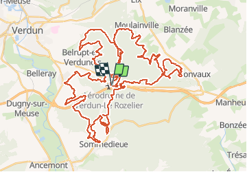
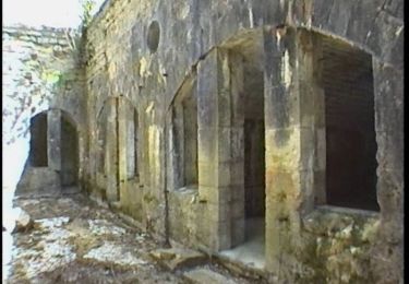
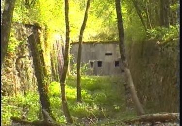
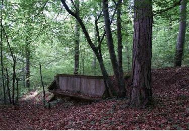
Randonnée V.T.T. de 69 km à découvrir à Grand Est, Meuse, Sommedieue. Cette randonnée est proposée par Tollard.

Description

toptoptop

Profil altimétrique

Localisation

Pays :
France
Région :
Grand Est
Département/Province :
Meuse
Commune :
Sommedieue
Localité :
Unknown
Départ:(UTM)
680352 ; 5444005 (31U) N.

Randonnées à proximité

Randonnée V.T.T. Sommedieue - Espace VTT FFC Verdun le Rozelier - Circuit n°07 - Sommedieu - Photo
V.T.T.
tracegps

V.T.T.

Très difficile
(2)
Sommedieue, Grand Est, Meuse, France
35 km | 45 km-effort
4h 0min
Oui
Randonnée Marche Belleray - grottes de la Falouses - Photo
Marche
ghislaine61

Marche

Moyen
(1)
Belleray, Grand Est, Meuse, France
9,7 km | 11 km-effort
2h 25min
Oui
Randonnée Marche Sommedieue - circuit de la Marjolaine - Photo
Marche
lolo55

Marche

Très facile
Sommedieue, Grand Est, Meuse, France
7,6 km | 9 km-effort
1h 58min
Non
Randonnée V.T.T. Belrupt-en-Verdunois - Sentier de St Airy (Petit tour) - Belrupt-en-Verdunois - Photo
V.T.T.
tracegps

V.T.T.

Facile
Belrupt-en-Verdunois, Grand Est, Meuse, France
6,5 km | 8,6 km-effort
30min
Oui
Randonnée Marche Belrupt-en-Verdunois - Sentier de St Airy (Petit tour) - Belrupt-en-Verdunois - Photo
Marche
tracegps

Marche

Facile
Belrupt-en-Verdunois, Grand Est, Meuse, France
6,5 km | 8,6 km-effort
1h 40min
Oui
Randonnée V.T.T. Belrupt-en-Verdunois - Sentier de St Airy (Grand tour) - Belrupt-en-Verdunois - Photo
V.T.T.
tracegps

V.T.T.

Facile
Belrupt-en-Verdunois, Grand Est, Meuse, France
9 km | 11,5 km-effort
1h 0min
Oui
Randonnée Marche Belrupt-en-Verdunois - Sentier de St Airy (Grand tour) - Belrupt-en-Verdunois - Photo
Marche
tracegps

Marche

Moyen
Belrupt-en-Verdunois, Grand Est, Meuse, France
9 km | 11,5 km-effort
2h 15min
Oui
Randonnée V.T.T. Sommedieue - Le Fond du Mal Patu - Sommedieue - Photo
V.T.T.
tracegps

V.T.T.

Facile
Sommedieue, Grand Est, Meuse, France
9,6 km | 12,6 km-effort
1h 0min
Oui
Randonnée Marche Sommedieue - Le Fond du Mal Patu - Sommedieue - Photo
Marche
tracegps

Marche

Moyen
Sommedieue, Grand Est, Meuse, France
9,6 km | 12,6 km-effort
2h 30min
Oui


Fermer
Mes abonnements