Randonnée Randonnée équestre Lachapelle-sous-Chaux - Lachapelle-sous-chaux / Centre équestre La Jumenterie - Photo

Lachapelle-sous-chaux / Centre équestre La Jumenterie

 battaglia
battaglia

Utilisateur

© OpenStreetMap contributors
Longueur
Longueur
58 km
Altitude max
Altitude max
1240 m
Dénivelé positif
Dénivelé positif
2331 m
Km-Effort
Km-Effort  
89 km
Altitude min
Altitude min
407 m
Dénivelé négatif
Dénivelé négatif
2332 m
Boucle
Boucle
Oui
Date de création :
2020-09-10 07:34:09.749
Dernière modification :
2020-09-10 09:30:22.246

(0 Avis)

Randonnée équestre
Randonnée équestre
5h14
Difficulté : Difficile

Scannez ce code QR pour ouvrir la randonnée dans l'application SityTrail

Application GPS de randonnée GRATUITE

Logo SityTrail SityTrail

IGN / Instituts géographiques

Télécharger SityTrail sur l'App Store Télécharger SityTrail sur Google Play

Logo SityTrail SityTrail World

Le monde est à vous

Télécharger SityTrail sur l'App Store Télécharger SityTrail sur Google Play Télécharger SityTrail sur Huawei AppGallery

À propos

Randonnée Randonnée équestre de 58 km à découvrir à Bourgogne-Franche-Comté, Territoire-de-Belfort, Lachapelle-sous-Chaux. Cette randonnée est proposée par battaglia.

Profil altimétrique

Localisation

Pays :
France
Région :
Bourgogne-Franche-Comté
Département/Province :
Territoire-de-Belfort
Commune :
Lachapelle-sous-Chaux
Localité :
Unknown
Départ:(UTM)
336058 ; 5285868 (32T) N.

Randonnées à proximité

Randonnée Marche Auxelles-Haut - Rando-planche belles filles par auxelle haut - Photo
Marche
benoit747

Marche

Moyen
(3)
Auxelles-Haut, Bourgogne-Franche-Comté, Territoire-de-Belfort, France
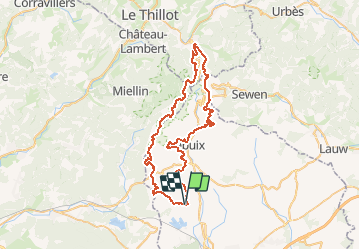
14,6 km | 23 km-effort
4h 55min
Oui
Randonnée Marche Sermamagny - Veronne PC - Photo
Marche
Papamoju

Marche

Très facile
(2)
Sermamagny, Bourgogne-Franche-Comté, Territoire-de-Belfort, France
8,1 km | 9 km-effort
1h 59min
Oui
Randonnée Randonnée équestre Lachapelle-sous-Chaux - Lachapelle-sous-chaux / Planche des belles filles - Photo
Randonnée équestre
battaglia

Randonnée équestre

Difficile
(1)
Lachapelle-sous-Chaux, Bourgogne-Franche-Comté, Territoire-de-Belfort, France
25 km | 37 km-effort
4h 26min
Oui
Randonnée Marche Auxelles-Haut - auxelles hauts - Photo
Marche
Raymond Bacholle

Marche

Moyen
Auxelles-Haut, Bourgogne-Franche-Comté, Territoire-de-Belfort, France
16 km | 27 km-effort
4h 20min
Oui
Randonnée V.T.T. Chaux - mont jean Giro  - Photo
V.T.T.
olivier90

V.T.T.

Très facile
(1)
Chaux, Bourgogne-Franche-Comté, Territoire-de-Belfort, France
24 km | 32 km-effort
2h 4min
Oui
Randonnée Marche Giromagny - Le sentier des mines - Giromagny - Photo
Marche
tracegps

Marche

Moyen
(1)
Giromagny, Bourgogne-Franche-Comté, Territoire-de-Belfort, France
6,4 km | 9,4 km-effort
2h 0min
Oui
Randonnée Marche Sermamagny - Le Malsaucy - Photo
Marche
ISATR

Marche

Très facile
Sermamagny, Bourgogne-Franche-Comté, Territoire-de-Belfort, France
9,7 km | 11,2 km-effort
2h 10min
Oui
Randonnée Marche Auxelles-Haut - boucle auxelles-haut, super planche et étang des belles filles  - Photo
Marche
fbienmuller

Marche

Moyen
Auxelles-Haut, Bourgogne-Franche-Comté, Territoire-de-Belfort, France
15,2 km | 24 km-effort
4h 41min
Oui
Randonnée Marche Chaux - Chaux  - Photo
Marche
klopbill

Marche

Très facile
Chaux, Bourgogne-Franche-Comté, Territoire-de-Belfort, France
10 km | 13 km-effort
3h 40min
Oui


Fermer
Mes abonnements