![](/images/other/stat-length.png)
![Randonnée Marche Beaufort - st gyerin. Grand mont. lacs de la tempête - Photo](https://media.geolcdn.com/t/1900/400/ext.pjpeg?maxdim=2&url=https%3A%2F%2Fmedia.geolcdn.com%2Ff%2F78bc4139-f31e-43e6-a3fd-b1c8aa2e54c1.jpg)
st gyerin. Grand mont. lacs de la tempête
olivecoco
Utilisateur
![Longueur](/images/other/stat-length.png)
Longueur
15,8 km
![Altitude max](https://static1.geolcdn.com/siteimages/upload/files/1508320355ic_sort_altitude_max_24dp.png)
Altitude max
2670 m
![Dénivelé positif](https://static1.geolcdn.com/siteimages/upload/files/1508320355ic_sort_den_pos_24dp.png)
Dénivelé positif
1351 m
![Km-Effort](/images/other/stat-length.png)
Km-Effort
34 km
![Altitude min](https://static1.geolcdn.com/siteimages/upload/files/1508320355ic_sort_altitude_min_24dp.png)
Altitude min
1509 m
![Dénivelé négatif](https://static1.geolcdn.com/siteimages/upload/files/1508320355ic_sort_den_neg_24dp.png)
Dénivelé négatif
1354 m
![Boucle](https://static1.geolcdn.com/siteimages/upload/files/16400158638029165_repeat_loop_refresh_sync_direction_icon.png)
Boucle
Oui
Date de création :
2020-09-08 08:01:44.92
Dernière modification :
2020-09-11 10:54:49.613
![Marche](https://static1.geolcdn.com/sitytour/trail-icons/101.png)
7h14
Difficulté : Moyen
![Scannez ce code QR pour ouvrir la randonnée dans l'application SityTrail](https://capi.geolives.com/qq0zvz2zws4bq2lad0pu/sitytour/trails/2546562/qr.png?size=200)
Application GPS de randonnée GRATUITE
À propos
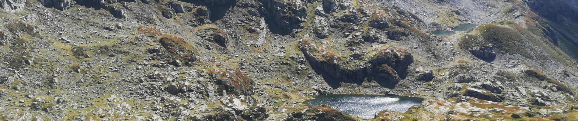
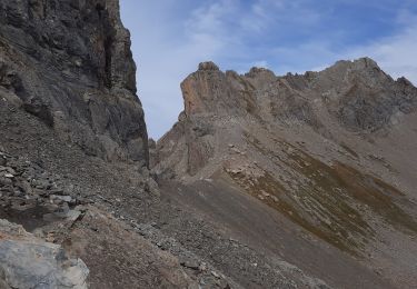
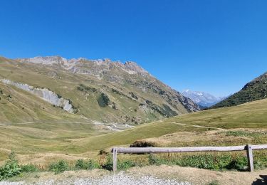
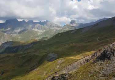
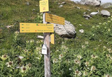
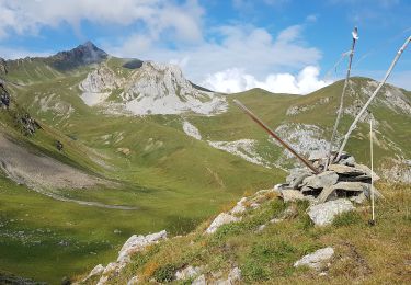
Randonnée Marche de 15,8 km à découvrir à Auvergne-Rhône-Alpes, Savoie, Beaufort. Cette randonnée est proposée par olivecoco.
Description
Très jolie boucle, variée avec panorama à 360 incroyable au grand mont et descente sur ces perles que sont les lacs de la tempête
Localisation
Pays :
France
Région :
Auvergne-Rhône-Alpes
Département/Province :
Savoie
Commune :
Beaufort
Localité :
Unknown
Départ:(Dec)
Départ:(UTM)
311662 ; 5058115 (32T) N.
Commentaires
Randonnées à proximité
![Randonnée Marche Beaufort - D'Arêches au Col de Pré par le hameau de Boudin - Photo](https://media.geolcdn.com/t/375/260/ext.jpg?maxdim=2&url=https%3A%2F%2Fservices.sitytrail.com%2FGeolivesWS%2FDownloadMedia.ashx%3FTrailID%3D112688%26Media%3D11533_5.jpg)
![Marche Marche](https://static1.geolcdn.com/sitytour/trail-icons/101.png)
D'Arêches au Col de Pré par le hameau de Boudin
Marche
Moyen
(1)
Beaufort,
Auvergne-Rhône-Alpes,
Savoie,
France
![](/images/other/stat-length.png)
8,2 km | 17,9 km-effort
4h 0min
![](https://static1.geolcdn.com/siteimages/upload/files/16400158638029165_repeat_loop_refresh_sync_direction_icon.png)
Oui
![Randonnée Marche Beaufort - lac de Presset et passeur de la Mintaz (belvédère de la Pierra Menta) - Photo](https://media.geolcdn.com/t/375/260/ext.jpg?maxdim=2&url=https%3A%2F%2Fmedia.geolcdn.com%2Ff%2F0e1a7432-483a-440c-958e-0a3e3d697f7b.jpg)
![Marche Marche](https://static1.geolcdn.com/sitytour/trail-icons/101.png)
lac de Presset et passeur de la Mintaz (belvédère de la Pierra Menta)
Marche
Difficile
Beaufort,
Auvergne-Rhône-Alpes,
Savoie,
France
![](/images/other/stat-length.png)
11,6 km | 24 km-effort
2h 57min
![](https://static1.geolcdn.com/siteimages/upload/files/16400158638029165_repeat_loop_refresh_sync_direction_icon.png)
Oui
![Randonnée Ski de randonnée Beaufort - Anticime de la pointe de la grande journée, montée couloir du grepets - Photo](https://media.geolcdn.com/t/375/260/ext.jpg?maxdim=2&url=https%3A%2F%2Fmedia.geolcdn.com%2Ff%2F8dfd1937-3bd4-42bd-a4fa-284d4bb8802e.jpg)
![Ski de randonnée Ski de randonnée](https://static1.geolcdn.com/sitytour/trail-icons/503.png)
Anticime de la pointe de la grande journée, montée couloir du grepets
Ski de randonnée
Difficile
Beaufort,
Auvergne-Rhône-Alpes,
Savoie,
France
![](/images/other/stat-length.png)
13,4 km | 30 km-effort
4h 48min
![](https://static1.geolcdn.com/siteimages/upload/files/16400158638029165_repeat_loop_refresh_sync_direction_icon.png)
Oui
![Randonnée Marche Beaufort - Col de Roche Plane - Photo](https://media.geolcdn.com/t/375/260/ext.jpg?maxdim=2&url=https%3A%2F%2Fmedia.geolcdn.com%2Ff%2F73cc5e19-0c97-48f8-b76a-023f89d535d0.jpg)
![Marche Marche](https://static1.geolcdn.com/sitytour/trail-icons/101.png)
Col de Roche Plane
Marche
Très difficile
Beaufort,
Auvergne-Rhône-Alpes,
Savoie,
France
![](/images/other/stat-length.png)
12,2 km | 27 km-effort
6h 12min
![](https://static1.geolcdn.com/siteimages/upload/files/16400158638029165_repeat_loop_refresh_sync_direction_icon.png)
Oui
![Randonnée Marche Beaufort - Brèche de Parozan - Photo](https://media.geolcdn.com/t/375/260/ext.jpg?maxdim=2&url=https%3A%2F%2Fmedia.geolcdn.com%2Ff%2F728ef179-a406-42e9-bcd0-e3fb4fea1422.jpg)
![Marche Marche](https://static1.geolcdn.com/sitytour/trail-icons/101.png)
Brèche de Parozan
Marche
Très difficile
Beaufort,
Auvergne-Rhône-Alpes,
Savoie,
France
![](/images/other/stat-length.png)
9,6 km | 23 km-effort
4h 29min
![](https://static1.geolcdn.com/siteimages/upload/files/16400158638029165_repeat_loop_refresh_sync_direction_icon.png)
Oui
![Randonnée Marche Aime-la-Plagne - Lac de Presset par la Piera Menta depuis le Cornet d'Arêches - Photo](https://media.geolcdn.com/t/375/260/ext.jpg?maxdim=2&url=https%3A%2F%2Fmedia.geolcdn.com%2Ff%2Ffa489cc8-f4d2-4b43-8b50-128576704080.jpg)
![Marche Marche](https://static1.geolcdn.com/sitytour/trail-icons/101.png)
Lac de Presset par la Piera Menta depuis le Cornet d'Arêches
Marche
Moyen
(1)
Aime-la-Plagne,
Auvergne-Rhône-Alpes,
Savoie,
France
![](/images/other/stat-length.png)
17 km | 32 km-effort
6h 49min
![](https://static1.geolcdn.com/siteimages/upload/files/16400158638029165_repeat_loop_refresh_sync_direction_icon.png)
Oui
![Randonnée Marche Beaufort - Lac d'Amour - Photo](https://media.geolcdn.com/t/375/260/ext.jpg?maxdim=2&url=https%3A%2F%2Fmedia.geolcdn.com%2Ff%2Fe6ab2c21-bd39-4b77-81f1-114535a0765d.jpg)
![Marche Marche](https://static1.geolcdn.com/sitytour/trail-icons/101.png)
Lac d'Amour
Marche
Facile
Beaufort,
Auvergne-Rhône-Alpes,
Savoie,
France
![](/images/other/stat-length.png)
21 km | 35 km-effort
6h 22min
![](https://static1.geolcdn.com/siteimages/upload/files/16400158638029165_repeat_loop_refresh_sync_direction_icon.png)
Oui
![Randonnée Marche Beaufort - BEAUFORTIN: DE TREICOL AU REFUGE DE PRESSET - Photo](https://media.geolcdn.com/t/375/260/ext.jpg?maxdim=2&url=https%3A%2F%2Fmedia.geolcdn.com%2Ff%2Fb55af32d-175e-4c65-8b45-e395808907f4.jpg)
![Marche Marche](https://static1.geolcdn.com/sitytour/trail-icons/101.png)
BEAUFORTIN: DE TREICOL AU REFUGE DE PRESSET
Marche
Moyen
Beaufort,
Auvergne-Rhône-Alpes,
Savoie,
France
![](/images/other/stat-length.png)
9,1 km | 19,1 km-effort
3h 10min
![](https://static1.geolcdn.com/siteimages/upload/files/16400158638029165_repeat_loop_refresh_sync_direction_icon.png)
Non
![Randonnée Marche Aime-la-Plagne - Beaufortain: Autour de La Pierra Menta: J6 - Ref. de La Coire - Pk Laval - Photo](https://media.geolcdn.com/t/375/260/ext.jpg?maxdim=2&url=https%3A%2F%2Fmedia.geolcdn.com%2Ff%2F85d2bac9-c38a-45a8-9da1-d0cde71c6974.jpg)
![Marche Marche](https://static1.geolcdn.com/sitytour/trail-icons/101.png)
Beaufortain: Autour de La Pierra Menta: J6 - Ref. de La Coire - Pk Laval
Marche
Moyen
Aime-la-Plagne,
Auvergne-Rhône-Alpes,
Savoie,
France
![](/images/other/stat-length.png)
10,4 km | 17 km-effort
3h 21min
![](https://static1.geolcdn.com/siteimages/upload/files/16400158638029165_repeat_loop_refresh_sync_direction_icon.png)
Non