


Sentheim - Bergwald - Eichwald - Guevenheim - Sentheim

patrickbeyrath
Utilisateur
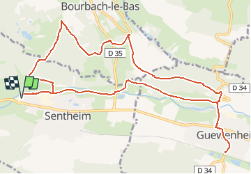

Longueur
13,4 km

Altitude max
446 m

Dénivelé positif
239 m
Km-Effort
16,6 km

Altitude min
328 m

Dénivelé négatif
239 m
Boucle
Oui
Date de création :
2020-10-23 05:50:53.702
Dernière modification :
2020-10-23 06:04:37.39
--
Difficulté : Facile

Application GPS de randonnée GRATUITE
 SityTrail
IGN / Instituts géographiques
SityTrail Plus
Le monde est à vous
À propos
Randonnée A pied de 13,4 km à découvrir à Grand Est, Haut-Rhin, Sentheim. Cette randonnée est proposée par patrickbeyrath.
Description
Repas au restaurant de la Gare à Guewenheim
Localisation
Pays :
France
Région :
Grand Est
Département/Province :
Haut-Rhin
Commune :
Sentheim
Localité :
Unknown
Départ:(Dec)
Départ:(UTM)
353278 ; 5291265 (32T) N.
Commentaires