Randonnée Marche Hohrod - Hohrodberg - Le Linge - Photo

Hohrodberg - Le Linge

 sit68000
sit68000

Utilisateur

© OpenStreetMap contributors
Longueur
Longueur
6,5 km
Altitude max
Altitude max
1048 m
Dénivelé positif
Dénivelé positif
285 m
Km-Effort
Km-Effort  
10,3 km
Altitude min
Altitude min
811 m
Dénivelé négatif
Dénivelé négatif
290 m
Boucle
Boucle
Oui
Date de création :
2014-12-10 00:00:00.0
Dernière modification :
2014-12-10 00:00:00.0

(2 Avis)

Marche
Marche
2h02
Difficulté : Facile

Scannez ce code QR pour ouvrir la randonnée dans l'application SityTrail

Application GPS de randonnée GRATUITE

Logo SityTrail SityTrail

IGN / Instituts géographiques

Télécharger SityTrail sur l'App Store Télécharger SityTrail sur Google Play

Logo SityTrail SityTrail World

Le monde est à vous

Télécharger SityTrail sur l'App Store Télécharger SityTrail sur Google Play Télécharger SityTrail sur Huawei AppGallery

À propos

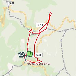
Randonnée Marche de 6,5 km à découvrir à Grand Est, Haut-Rhin, Hohrod. Cette randonnée est proposée par sit68000.

Description

Accès :
Depuis Munster par Hohrod (D5 b1) jusqu'au parking au-dessus de Hohrodberg.
Départ : Face au parking.
Durée : 2h
Distance : 5,8km
Balisage : Circuit historique
Dénivelé : 270m

Prendre le sentier en face du parking. Les n° du parcours correspondent aux bornes explicatives, de 1 à 24.
Carte IGN TOP 25 n°3718

Profil altimétrique

Localisation

Pays :
France
Région :
Grand Est
Département/Province :
Haut-Rhin
Commune :
Hohrod
Localité :
Unknown
Départ:(Dec)
Départ:(UTM)
360402 ; 5325473 (32U) N.

Commentaires

Veuillez vous connecter pour laisser un commentaire ou une note


Randonnées à proximité

Randonnée Randonnée équestre Orbey - 2020-06-28 WE Orbey Petit Hohnack Glasborn - Photo
Randonnée équestre
GUIDE
holtzv

Randonnée équestre

Difficile
(1)
Orbey, Grand Est, Haut-Rhin, France
22 km | 31 km-effort
4h 5min
Oui
Randonnée Randonnée équestre Orbey - 2020-06-27 WE Orbey Noir Gazon Vert Forlet - Photo
Randonnée équestre
GUIDE
holtzv

Randonnée équestre

Moyen
(1)
Orbey, Grand Est, Haut-Rhin, France
21 km | 30 km-effort
3h 59min
Oui
Randonnée Autre activité Soultzeren - Totom 4 lacs - Photo
Autre activité
dinozore

Autre activité

Moyen
(1)
Soultzeren, Grand Est, Haut-Rhin, France
15,6 km | 26 km-effort
4h 37min
Oui
Randonnée Marche Munster - De Munster aux 3 Fours (Aller) - Munster - Photo
Marche
tracegps

Marche

Difficile
(1)
Munster, Grand Est, Haut-Rhin, France
14,8 km | 27 km-effort
5h 0min
Non
Randonnée Marche Hohrod - Circuit historique 1914-18 Hohrodberg - Linge - Photo
Marche
VacheKiri67

Marche

Moyen
(1)
Hohrod, Grand Est, Haut-Rhin, France
14 km | 19,8 km-effort
5h 50min
Oui
Randonnée Marche Munster - 19.06.13.Munster  - Photo
Marche
ROPPJP

Marche

Très facile
(1)
Munster, Grand Est, Haut-Rhin, France
7,3 km | 10,6 km-effort
2h 10min
Oui
Randonnée Marche Soultzeren - Tanet-Gazon du faing par lac vert et retour sommet du Tanet - Photo
Marche
ride-in-Elsass

Marche

Moyen
(1)
Soultzeren, Grand Est, Haut-Rhin, France
10 km | 15,6 km-effort
4h 24min
Oui
Randonnée V.T.T. Labaroche - Tour de Labaroche - Photo
V.T.T.
tracegps

V.T.T.

Moyen
(1)
Labaroche, Grand Est, Haut-Rhin, France
23 km | 31 km-effort
3h 30min
Oui
Randonnée Randonnée équestre Gunsbach - Le petit Hohnack - verkort (23) - Photo
Randonnée équestre
eddyvermeulen1

Randonnée équestre

Facile
(1)
Gunsbach, Grand Est, Haut-Rhin, France
13,1 km | 18,4 km-effort
2h 25min
Oui


Fermer
Mes abonnements