


XONRUPT

surceneux
Utilisateur
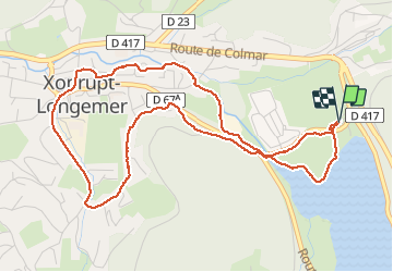

Longueur
5,4 km

Altitude max
776 m

Dénivelé positif
81 m
Km-Effort
6,5 km

Altitude min
717 m

Dénivelé négatif
82 m
Boucle
Oui
Date de création :
2021-01-11 13:51:31.352
Dernière modification :
2021-01-11 15:49:20.022
1h10
Difficulté : Très facile

Application GPS de randonnée GRATUITE
 SityTrail
IGN / Instituts géographiques
SityTrail Plus
Le monde est à vous
À propos
Randonnée Marche de 5,4 km à découvrir à Grand Est, Vosges, Xonrupt-Longemer. Cette randonnée est proposée par surceneux.
Description
Tour de XONRUPT depuis longemer
Localisation
Pays :
France
Région :
Grand Est
Département/Province :
Vosges
Commune :
Xonrupt-Longemer
Localité :
Unknown
Départ:(Dec)
Départ:(UTM)
347105 ; 5327216 (32U) N.
Commentaires